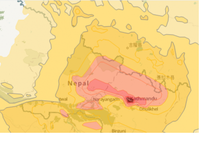
On Saturday, 25 April 2015 a 7.8 magnitude earthquake hit Nepal, India, Bangladesh, and India with several aftershocks following on Saturday and Sunday. GDACS estimates that 6.5 million people are affected. Several actors from the satellite and mapping communities have become active in supporting response efforts in the region; particularly in Nepal, which was most severely affected.
- Copernicus Emergency Mapping Service (EMS) was activated by EC Services|DG ECHO. Maps are available at the EMS webpage. Regular updates on mapping products are also available via subscription to the Copernicus EMS RSS feed.
- The International Charter on Space and Major Disasters was activated by the Disaster Management Support (DMS) Programme Office, Indian Space Research Organisation (ISRO) and by UNITAR/UNOSAT on behalf of UNICEF. Project Managers are National Remote Sensing Center in China (NRSC) and ISRO. Mapping products will be made available at the webpage of the Disasters Charter.
- Sentinel Asia was activated. Satellite data products are available via the Sentinel Asia webpage as well as via the Sentinel Asia Web-GIS.
- DLR's ZKI-DE service was activated. Maps are available via DLR's ZKI webpage.
- As the result of a joint effort of the International Working Group on Satellite-based Emergency Mapping (IWG-SEM), Copernicus provides a feed aggregator with an overview on ongoing satellite-based emergancy mapping activities.
Several actors of the crowdsource mapping community have also become involved. Tomnod, a service supported by satellite imagery provider DigitalGlobe, has issued a call to the community to help search high resolution satellite imagery for damaged buildings, major destruction and damaged roads. An overview of other crowdsource mappers, including the Humanitarian OpenStreetMap or Crisis Mappers, is provided here.
UN-SPIDER has compiled all relevant sources and links to datasets on a dedicated page. Additionally to the mechanisms listed above, these also include satellite imagery and reference maps.

