International Centre for Integrated Mountain Development (ICIMOD)
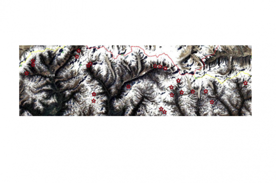
The identification of critical glacial lakes is based on remote sensing method in which several criteria related to glacial lakes, glaciers and physical condition of surrounding area is considered to assess potential for future outburst and possible glacial lake outburst flood (GLOF).
Visual observation and mapping of glacial lakes and associated glaciers along with physical features in the vicinity using Landsat data series provides vital information to identify critical glacial lakes with potential for an outburst in future. This allows early identification of potential hazard and makes a timely investment on risk management interventions including outburst mitigation options.
Evolution of glacial lake is studied using time series Landsat data which in conjunction with other factors like size of mother glacier and proximity to, type of glacial lake, moraine condition, and physical condition of lake
surrounding, the criticality of the glacial lake is assessed. Criteria for identifying critical glacial lake is presented in Ives et al., 2010. Ives, JD; Shrestha, RB; Mool, PK (2010) Formation of glacial lakes in the Hindu Kush- Himalayas and GLOF risk assessment. Kathmandu: ICIMOD.
There are over 200 critical glacial lakes in the Hindu Kush Himalayan region some of which are monitored regularly using remote sensing and occasionally in the field
The approach provides a simple methodology using freely available data to identify looming hazard up in the difficult and inaccessible terrain.
Mool, P.K.; Bajracharya, S.R.; Joshi, S.P. (2001) Inventory of Glaciers, Glacial Lakes, and Glacial Lake Outburst Flood Monitoring and Early Warning Systems in the Hindu Kush Himalayan Region – Nepal. Kathmandu: ICIMOD
Mool, P.K.; Bajracharya, S.R.; Joshi, S.P. (2001) Inventory of Glaciers, Glacial Lakes, and Glacial Lake Outburst Flood Monitoring and Early Warning Systems in the Hindu Kush Himalayan Region – Bhutan. Kathmandu: ICIMOD