  • English
  • Español
  • Français

United
Nations


Office for Outer Space Affairs
UN-SPIDER Knowledge Portal

  • Home
  • About Us
    • What is UN-SPIDER?
    • About UNOOSA
    • Publications
    • Jobs
    • Meet the Team
    • Contact
  • Space Application
    • Satellite Technology
    • Emergency Mechanisms
    • Recovery Mechanisms
    • International Asteroid Warning Network
    • Space Mission Planning Advisory Group
    • International Space Weather Initiative
    • Space Technologies in the UN
    • User Stories
  • Links & Resources
    • Data Applications
      • Disaster Recovery
    • Data Sources
    • GIS and Remote Sensing Software
    • Online Learning Resources
    • Institutions
  • Risks & Disasters
    • Disaster Risk Management
    • Early Warning Systems
    • Emergency and Disaster Management
    • Natural Hazards
    • Sendai Framework
    • The UN and Disaster Risk Management
    • The UN and Early Warning
    • The UN and Disaster Management
  • Advisory Support
    • Advisory Missions
    • Emergency Support
    • Virtual Advisory Support
    • Recommended Practices
    • Training Activities
    • Practical Uses
  • Network
    • Regional Support Offices
    • GP-STAR
    • MHEWS
    • IWG-SEM
  • Projects
    • SPEAR
    • SEWS-D
    • EvIDENz
    • Flood GUIDE
    • CommonSpace Initiative
    • Tonga Pilot Project
  • News & Events
    • News
    • Events Calendar
    • UN-SPIDER Events Archive

Breadcrumb

  • Home
  • KOMPSAT-5 / Arirang-5
  • KOMPSAT-5 / Arirang-5

KOMPSAT-5 / Arirang-5

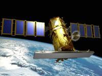
KOMPSAT-5 is an earth observation satellite equipped with Korea's first all-weather SAR.
The SAR mounted on KOMPSAT-5 emits microwaves to an object on the ground and synthesizes the reflected signal to produce an image. It enables ground observation even during nighttime and poor weather conditions.
As the SAR image can supplement the optical camera, which can record only the visible light spectrum, it is utilized in mutual supplementary operations with the high-resolution optical images of KOMPSAT-3 and KOMPSAT-3A.
KOMPSAT-5 observes the Korean Peninsula four times a day. The transmitted image data are used for public safety, natural disaster forecasts, land/resource management and environmental monitoring.

The primary mission of the KOMPSAT-5 system is to provide high resolution mode SAR images of 1 meter resolution, standard mode SAR images of 3 meter resolution and wide swath mode SAR images of 20 meter resolution with viewing conditions of the incidence angle of 45 degrees using the COSI (COrea SAR Instrument) payload, for meeting GOLDEN mission objectives.

The secondary mission of KOMPSAT-5 is to generate the atmospheric sounding profile and support radio occultation science using AOPOD (atmospheric occultation and precision orbit determination) secondary payload which is composed of a dual frequency GPS receiver and a laser retroreflector array (LRRA).

Instruments:
COSI (Corea SAR Instrument)
AOPOD (Atmosphere Occultation and Precision Orbit Determination)
LRRA (Laser Retro Reflector Array)

22 Aug 2013
5years
Sun synchronous
99 minutes
KARI
Cartography, land use and planning, disaster monitoring
Drought
Glacial Lake Outburst
Landslide
Earthquake
Flood
Forest Fire
Mass Movement
Tsunami
Volcanic Eruption
No
Information about KOMPSAT-5 on KARI web page

Footer menu

  • Contact
  • Terms of Use

User account menu

  • Log in