This is event is available for participation on an ongoing basis
Introduction
Globally there is growing interest in better understanding solar-terrestrial interactions, particularly patterns and trends in space weather. This is not only for scientific reasons, but also because the reliable operation of ground-based and space-based assets and infrastructures is increasingly dependent on their robustness against the detrimental effects of space weather.
This is event is available for participation on an ongoing basis
Objectives
At this first stakeholder meeting the Space4Water stakeholder community has an opportunity to get to meet and know each other in person. The workshop's objectives include the identification of
shared community objectives for the Space4Water community
approaches to assessing user needs within the community and water related sectors towards the space sector
approaches to facilitate matchmaking between users with needs and existing gaps and stakeholders who have solutions to (partial) problems
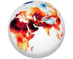
In June and July 2022, heatwaves struck Europe, North Africa, the Middle East, and Asia, as temperatures climbed above 40 degrees Celsius (104 degrees Fahrenheit) in places and broke many long-standing records.
This is event is available for participation on an ongoing basis
The United Nations General Assembly has designated 13 October as the International Day for Disaster Risk Reduction (IDDRR) to promote a global culture of disaster risk reduction. The 2022 edition takes place during the Midterm Review of the Sendai Framework, which will conclude at a High-level Meeting of the General Assembly in May 2023 with a political declaration.
This is event is available for participation on an ongoing basis
The Committee of Experts on Global Geospatial Information Management (UN-GGIM) will be convening the second United Nations World Geospatial Information Congress (UNWGIC) in Hyderabad, India from 10-14 October 2022.
Technicians of the Central American Council for Housing and Human Settlements (CCVAH) of El Salvador, Honduras, and the Dominican Republic; Representatives of the Metropolitan Areas of Honduras & El Salvador; and the Central American Secretariat for Social Integration (SISCA), visited the United Nations Bonn Campus. They met with experts from the United Nations University, learning about the academic work linked to climate adaptation, resilient urban development, environmental risk, and mobility.
This is event is available for participation on an ongoing basis
The twelfth session of the United Nations Committee of Experts on Global Geospatial Information Management (UN-GGIM) will be held from 3 - 5 August 2022 at the United Nations Headquarters in New York. UN-GGIM, comprising experts designated by the Governments of Member States, seeks to promote international cooperation in global geospatial information management and provide a forum for coordination and dialogue among Member States, and between Member States and relevant international organizations.
This is event is available for participation on an ongoing basis
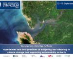
UN/AUSTRIA SYMPOSIUM 2022
Space for climate action: experiences and best practices in mitigating and adapting to climate change and supporting sustainability on Earth
The 2022 UN/Austria Symposium "Space for climate action: experiences and best practices in mitigating and adapting to climate change and supporting sustainability on Earth" will take place from 13 to 15 September online. The focus of the symposium is to showcase the most recent initiatives, experiences and best practices in mitigating and adapting to climate change and supporting sustainability on Earth.