![]()
United
Nations
Glacial Lake Outburst

Definition
Facts and figures
Further information
UN-SPIDER Regional Support Offices with hazard-specific expertise
Related content on the Knowledge Portal
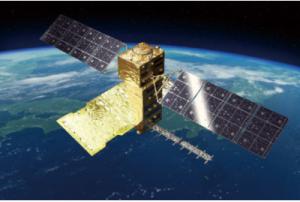
The Advanced Land Observing Satellite-4 (ALOS-4) is a satellite to observe the Earth's surface using its onboard phased array type L-band synthetic aperture radar (PALSAR-3). The L-band radar technology has continuously been developed in Japan. With further improved observation performance compared to the predecessor PALSAR-2 aboard the DAICHI-2 (ALOS-2), JAXA and its prime contractor, Mitsubishi Electric Corporation, are developing the satellite aiming at achieving both high resolution and a broader observation swath.
read more
Unlike observations by an optical sensor, radar images can be acquired day and night as it does not require sunlight. Moreover, since radio waves can penetrate cloud, the images can be obtained regardless of weather condition. The ALOS-4 will leverage these merits for observing and monitoring disaster-hit areas, forests, and sea ice. In addition, it will also challenge new areas such as monitoring infrastructure displacement.
The ALOS-4 will be equipped…01/07/2024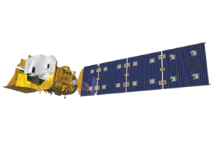
Landsat 9 was successfully launched on Monday, Sept. 27, 2021 from Vandenberg Space Force Base in California. Landsat 9 data is publicly available from USGS.
Landsat 9—a partnership between NASA and the U.S. Geological Survey— continues the Landsat program’s critical role in monitoring, understanding and managing the land resources needed to sustain human life.
Today’s increased rates of global land cover and land use change have profound consequences for weather and climate change, ecosystem function and services, carbon cycling and sequestration, resource management, the national and global economy, human health, and society.
Landsat is the only U.S. satellite system designed and operated to repeatedly observe the global land surface at a moderate scale that shows both natural and human-induced change.
Since reducing the risk of a Landsat data gap is a high priority of the U.S. Sustainable Land Imaging Program, Landsat 9 has a design very similar…
read more27/09/2021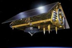 read more
The Sentinel-6 Michael Freilich satellite was launched into orbit on November 21, 2020. The launch was a culminated European-American effort that involved organisations from both sides of the atlantic. The European Space Agency (ESA), the European Organisation for the Exploitation of Meterological Satellites (EUMETSAT), the National Aeronautics and Space Administration (NASA), the National Oceanic and Atmospheric Administration (NOAA) and the National Centre for Space Studes (CNES) all collaborated together to make the launch of Sentinel-6 Michael Freilich a reality. The Sentinel-6 Michael Freilich satellite is the first of the Sentinel-6 satellites. An identical satellite, Sentinel-6B will follow in 2025. At an altitude of 1336 km the Sentinel-6 Michael Freilich satellite will use instruments on board to provide highly accurate measurements of the sea level in an effort to combat…
21/11/2020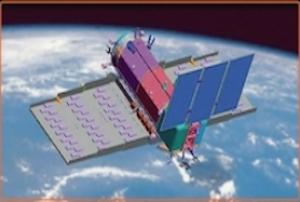
The Argentinean Microwaves Observation Satellite 1B (SAOCOM 1B) was launched into orbit on August 30, 2020 from Space Launch Complex 40 at Cape Canaveral Air Force Station in Florida, United States of America. Developed by the National Argentinean Space Commission (CONAE) in corporation with the Italian Space Agency (ASI), this new satellite joined SAOCOM 1A and four Italian COSMO-SkyMed to complete the Italian-Argentinean Satellite System for Emergency Management (SIASGE). The SAOCOM 1B satellite orbits at 620 km above the earth's surface and is fitted with a Synthetic Aperture Radar (SAR) sensor that makes use of microwaves in the electromagnetic L-band. The spatial resolution of its imagery ranges between 10 and 100 meters. The data collected by SAOCOM 1B helps monitor climatological disasters (forest fires, glacial lake outbursts, droughts) and hydrological disasters (landslides and floods).
30/08/2020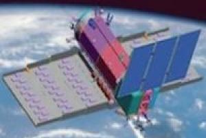
The Argentinean Microwaves Observation Satellite 1B (SAOCOM 1B) was launched into orbit on August 30, 2020 from Space Launch Complex 40 at Cape Canaveral Air Force Station in Florida, United States of America. Developed by the National Argentinean Space Commission (CONAE) in corporation with the Italian Space Agency (ASI), this new satellite joined SAOCOM 1A and four Italian COSMO-SkyMed to complete the Italian-Argentinean Satellite System for Emergency Management (SIASGE). The SAOCOM 1B satellite orbits at 620 km above the earth's surface and is fitted with a Synthetic…
read more30/08/2020
Cartosat-3 satellite is a third generation agile advanced satellite having high resolution imaging capability. Cartosat-3 will address the increased user’s demands for large scale urban planning, rural resource and infrastructure development, coastal land use and land cover etc.
27/11/2019
Cartosat-2 is an advanced remote sensing satellite with a single panchromatic camera (PAN) capable of providing scene-specific spot imageries for cartographic applications. The camera is designed to provide imageries with better than one meter spatial resolution and a swath of 10 km. The satellite will have high agility with capability to steer along and across the track up to + 45 degrees. It will be placed in a sun-synchronous polar orbit at an altitude of 630 km. It will have a revisit period of four days. The re-visit can be improved to one day with suitable orbit manoeuvres.
Several new technologies like two mirror on axis single camera, Carbon Fabric Reinforced Plastic based electro optic structure, lightweight, large size mirrors, JPEG like data compression, advanced solid state recorder, high-torque reaction wheels and high performance star sensors are being employed in Cartosat-2.
Beginning with Cartosat 2C, a Multi-spectral camera was added…
read more12/01/2018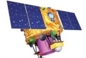
Cartosat-2 is an advanced remote sensing satellite with a single panchromatic camera (PAN) capable of providing scene-specific spot imageries for cartographic applications. The camera is designed to provide imageries with better than one meter spatial resolution and a swath of 10 km. The satellite will have high agility with capability to steer along and across the track up to + 45 degrees. It will be placed in a sun-synchronous polar orbit at an altitude of 630 km. It will have a revisit period of four days. The re-visit can be improved to one day with suitable orbit manoeuvres.
Several new technologies like two mirror on axis single camera, Carbon Fabric Reinforced Plastic based electro optic structure, lightweight, large size mirrors, JPEG like data compression, advanced solid state recorder, high-torque reaction wheels and high performance star sensors are being employed in Cartosat-2.
Beginning with Cartosat 2C, a Multi-spectral camera was added…
read more23/06/2017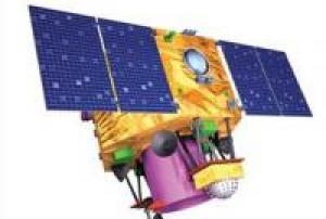 read more
Cartosat-2 is an advanced remote sensing satellite with a single panchromatic camera (PAN) capable of providing scene-specific spot imageries for cartographic applications. The camera is designed to provide imageries with better than one meter spatial resolution and a swath of 10 km. The satellite will have high agility with capability to steer along and across the track up to + 45 degrees. It will be placed in a sun-synchronous polar orbit at an altitude of 630 km. It will have a revisit period of four days. The re-…
15/02/2017
The AlSat-1B satellite was launched into orbit on September 26, 2016 from the Satish Dhawan Space Centre in Sriharikota, India. It was developed by the Algerian Space Agency (ASAL) in corporation with Surrey Satellite Technology Ltd (SSTL). The AlSat-1B satellite orbits at 670 km above the earth's surface and carries a 24m multispectral imager and a 12m panchromatic imager delivering images with a swath width of 140km. The satellite carries two High Speed Data Recorders and two Flash Mass Memory Units capable of recording, managing and storing image data for high speed downlink via S-Band and X-Band transmitters. The data collected by AlSat-1B helps monitor climatological disasters (forest fires, glacial lake outbursts, droughts) and hydrological disasters (landslides and floods).
26/09/2016
UN-SPIDER Regional Support Offices with hazard-specific expertise
![]()