![]()
United
Nations
Inundación
, processed by ESA, CC BY-SA 3.0 IGO.")
Definition
Facts and figures
Further information
UN-SPIDER Regional Support Offices with hazard-specific expertise
Related content on the Knowledge Portal
Heavy rains, sea level rise, flash floods, and coastal floods are expected to increase further the frequency and severity around the coastal areas of the United States. Since 2000, at least one flood has occurred in the U.S. on average on nearly 300 days per year. The NOAA database also shows that all 50 states and the District of Columbia were affected by flooding in 2021.
Flooding continues to be the country's most common and costly natural disaster, with flood-related disasters causing more than $85 billion in damage and economic losses in 2021 alone. According to Census Bureau, data collected earlier this year, natural disasters forced an estimated 3.4 million people in the U.S. to leave their homes in 2022, underscoring how climate-related weather events are already changing American communities.
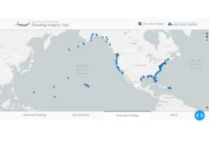
NASA has recently developed a Flooding Analysis Tool to allow practitioners and decision-makers to assess how sea level rise and other factors will...
read more16/03/2023
As the arrival of spring increases the risk of severe weather, NOAA's geostationary and polar-orbiting satellites, such as GOES East, GOES West, Suomi NPP, and NOAA-20, are closely monitoring the changing weather patterns.
GOES-16 and GOES-18 satellites provide real-time information about cloud properties, such as overshooting tops, gravity waves, and above-anvil cirrus plumes, as well as the temperature of cloud tops. This data helps forecasters track weather conditions, identify the severity of a storm, determine wind speeds, and predict the movement of the storm. In addition, these satellites use the Geostationary Lightning Mapper (GLM) instrument to monitor lightning activity, detecting total lightning activity and providing information about the extent and distance of lightning flashes. Scientists are also using AI to train the ProbSevere LightningCast model, which can predict lightning up to an hour before the first observation of lightning flashes, helping...
read more17/03/2023
Southern and Central provinces in Zambia are underwater after long-term rainfall starting 11 January, causing overflowing rivers. The floods, reported as “catastrophic” by Zambia’s Disaster Management and Mitigation Unit, have caused widespread damage to homes, farmland, and livestock. The floods have also left numerous communities isolated and sanitation facilities completely submerged, exposing the population to a high risk of waterborne diseases.
The International Water Management Institute (IWMI) has offered its support in developing a post-flood recovery strategy and strengthening digital climate agro-advisory services in Zambia.
Spokespersons at IWMI expressed the importance of enhancing emergency preparedness and response capacities to mitigate the impact of climate shocks. Furthermore, IWMI’s representatives also...
read moreRegional Support Offices mentioned:01/03/2023
The United Nations Platform for Space-based Information for Disaster Management and Emergency Response (UN-SPIDER) in collaboration with the German Aerospace Centre (DLR), the Global Flood Awareness System (GLOFAS) of the Copernicus Programme of the European Commission, and the University of Bonn’s Centre for Remote Sensing of Land Surfaces (ZFL), conducted an international training workshop on space-based technologies for flood management. The workshop was held at the UN Bonn Campus on 20-22 February 2023.
The workshop had an impressive turnout of nearly 30 attendees, including representatives from national disaster management agencies, space agencies, government agencies, and students enrolled in universities from various countries including Algeria, Barbados, Germany, Ghana, Italy, Kenya, Mexico, Mozambique, Nigeria, Pakistan, South Africa, Spain, Sri Lanka, Turkey, Uganda, and the United Kingdom.
The event aimed to increase the awareness of and developing skills...
read more28/02/2023

Term Parents
UN-SPIDER Regional Support Offices with hazard-specific expertise
![]()