
When a disaster occurs, situational awareness is imperative in decision making for response and emergency support. Information is needed on the scale of damage in an area and the location of the affected population, along with logistical information such as the location of hospitals, undamaged roads and bridges and communication infrastructure. In the days and weeks following a disaster, information concerning the international agencies and NGOs operating in the area and the distribution of resources is needed to ensure aid reaches those who need it most and efforts are not duplicated, wasting precious time. Disaster managers and responders require timely and accurate information to understand and communicate the situation on the ground to others.
Content
2. How are emergency response data provided from space?
2.1Organisations ivolved in satellite based mergency response
2.2 Emergency response for different disaster types using optical, thermal and SAR imagery
3. How can I access data for emergency response?
4. How is space-based data used for emergency response?
4.1 Satellite data in emergency response
4.2 Crowd sourced emergency response
1. What is the data used for?
The situation in a disaster region is often unclear, especially when remote areas are affected or when areas have become inaccessible as a result of a disaster. This can be further exacerbated by non-functional communication systems, the breakdown of national services and the difficulty of coordinating the high volume of actors involved in response efforts. There is great potential for applying space-related systems to the assessment of damage and the evaluation of the situation on the ground in the aftermath of natural and technological disasters. Rapid mapping and high-resolution imaging have become important support tools in emergency relief operations. Satellite maps and Geographic Information Systems are now regularly used in emergency response and humanitarian relief, including for logistics, staff security, distribution, transport and the setting up of telecommunication networks and refugee camps.
Satellite-based emergency mapping is the creation of maps, spatial data products and geo-information to provide crisis information and situational awareness using pre- and post-event imagery from satellites. Pre-disaster satellite imagery helps as a baseline to compare to imagery acquired just after the event, and to create maps of the area for those working on the ground. It can also help to identify further hazards caused by the initial disaster, such as potential areas of landsliding after an earthquake or volcanic eruption, or areas where prolonged inundation due to flooding may lead to new disease vectors. In the medium to longer term, satellite imagery can be used to identify internally displaced persons (IDP) camps, temporary shelters, and to carry out extensive damage assessments (of both the intensity and type of damage in an area), to help to plan for recovery and rehabilitation.
Satellite data and maps can provide an objective means of disaster assessment, and delineate the extent and intensity of a hazard much more rapidly than field investigations. Satellite systems and image analysis techniques have developed to an extent where EO instruments can effectively contribute to the management of both natural and manmade disasters.
2. How are emergency response data provided from space?
The data products for emergency response can broadly be grouped into three areas (as defined in the IWG-SEM emergency mapping guidelines, cf. www.iwg-sem.org):
- Pre-event maps or reference maps. The aim of a pre-event map is to quickly provide knowledge on the territory and assets prior to the emergency. The content consists of selected topographic features of the area affected by the disaster, in particular exposed assets and other available information that can assist the users in their specific crisis management tasks. The reference map is based on available reference data and the pre-event images, when available. If pre-event images are not available, the reference map will be based on reference data, the post-event image and ancillary information from other resources.
- Post-event maps including impact, delineation, grading, and damage level maps. Delineation maps provide an assessment of the event impact and extent. Delineation maps are directly derived from satellite images acquired immediately after the emergency event. When relevant, they may be combined with digital modelling and compared with archive information of similar event occurrences. Additionally, damage level maps provide an assessment of the damage (and event
ually of its evolution). Damage level maps are directly derived from satellite images acquired immediately after the emergency event. When relevant, they may be combined with digital modelling and compared with archive information of similar event occurrences. Damage level maps include the extent, type and damage specific to the event. They may also provide relevant and up-to-date information that is specific to critical infrastructures, transportation systems, aid and reconstruction logistics, government and community buildings, hazard exposure, displaced population, etc. - Situation update/ event monitoring maps. Impact/Delineation/Grading/Damage level/Post-Event maps can be updated to provide an assessment of the evolution of the event impact and extent.
These products are of great importance at a number of different stages of emergency response, with an especially high utility in the hours and days following an event. At all stages of the disaster cycle, communication and up-to-date information is needed for effective planning and action. Satellite imagery can aid in early warning and risk assessment in the pre-disaster phase, and to assess damage and coordinate relief in the post-disaster phase. Pre-event imagery can provide base maps showing roads, structures, schools, hospitals and other important infrastructure.
Through a combination of mandates, directives and humanitarian response coordination, space agencies and private satellite companies can release relevant data for an affected region to allow response teams, aid workers and researchers to gain insight into the situation and take quick and informed action. Post-event imagery can provide the basis for large crowd-sourced damage mapping campaigns, resulting in rapidly produced maps of remotely sensed disaster effects.
During the response and recovery phase of a disaster, only up-to-date, accurate and comprehensive image analysis products can significantly help in assessment and planning. Programming, delivery and analysis of satellite imagery needs to be within a response time of hours to a few days. However, raw imagery must be processed, orthorectified (the image must be stretched and ‘flattened’ to match the spatial accuracy of a map with consideration to location, elevation and sensor information) and interpreted to generate useful information for non-satellite expert users and to generate situation maps, reports and statistics for decision making. The full workflow from a request for assistance, through to satellite tasking, data acquisition, analysis, and map provision involves a complex chain of steps including the coordination of satellite commanding and data reception tasks, as well as preprocessing, correction, and analysis. This can take between a number of hours to a number of days, depending on the location of satellites and the scale of analysis. In addition to the expertise in image analysis, an equally important task is the generation of comprehensive and easy-to-use map products. For this purpose, reference data sets such as place names, road network, rivers, critical infrastructure, and topographic information are required.
Interaction with key actors in the user community is of great importance in addition to processing and analysis of satellite data, to ensure the products are useful and communicate information effectively. Earth-observation systems and information dissemination need to be linked with specifically trained decision makers, field staff of relief organizations and other stakeholders who will find it useful and be able to obtain it in an emergency situation. For example, in many regions data compatible with mobile devices that can be viewed without access to the internet can be of great use to those working on the ground.
In recent years crowd-sourced mapping, using volunteers around the world to map damaged areas, has grown through platforms such as Open Street Map and Tomnod, and though not without problems has been shown to be extremely useful in emergency response. A rapid remote, digital response for emergencies has been enabled by the high resolution and scope of current satellite sensors and teams of geographers, geodesists, geoscientists and volunteers around the globe. The end products are maps that show the extent of damage to an area, forecast what risks remain and areas where attention should be focused.
Changes to the way that maps are accessed have also influenced their use in disaster response. According to the International Telecommunications Union, only approximately 25% of the world’s population has access to the internet, however over 70% have access to mobile phones. There may be much greater opportunity for the use of mobile technologies to access mapping products than traditional computer systems.
2.1 Organisations involved in satellite based emergency response:
Different international emergency mechanisms can be activated in case of a disaster, such as the International Charter on Space and Major Disasters. The International Charter allows for a globally functioning mechanism to coordinate the tasking of multiple satellites and archiving systems in a very short time. It began as a collaboration between three space agencies in 2000, who came together to provide satellite imagery to UN member states in times of crisis, and has grown to a group of 15 members. The Charter provides satellite imagery to nations in need following large and sudden events which have a high impact on lives, infrastructure and the environment. Its capacities can be activated through a single access point which is available 24/7, under which space agencies contribute priority satellite tasking and organize map production for the disaster area. Between 2000 and 2014 there were 443 charter activations. The Universal Access initiative of the Charter allows any national disaster management authority to become an Authorized User of the Charter, and to submit requests to the Charter for emergency response. The only pre-requisites for national disaster management authorities to become authorized users is that it has the capacity to download and use maps and to submit an activation request in English.
The Copernicus Emergency Management Service (EMS) is a 24/7 service of the European Commission providing standardized products like reference maps, delineation maps, and grading maps. It can be activated in two modes: the rapid mapping mode and the risk and recovery mode. The EMS has had 135 activations in total since its launch in April 2012. Activations are received by member state’s civil protection agencies, European services, and UN agencies via DG ECHO. Rapid mapping services such as this can provide geo-spatial information to support emergency management activities in short time periods, and provide an overview of the reference situation on the ground, such as the terrain and hydrology of an area. It can also help to delineate the disaster’s damage, such as the flooded or burnt area or lava flow extent. An example of its use was the typhoon in the Philippines in 2013, where pre-alerts based on GDACS allowed for prediction of the typhoon path and early satellite tasking. A number of reference, delineation and damage grading maps were produced to assist with emergency response.

The German Aerospace Centre (DLR) has set up a dedicated Centre for Satellite Based Crisis Information (ZKI) to facilitate the use of its Earth-observation capacities for national and international response to disaster situations, humanitarian relief and civil security issues. DLR/ZKI closely works with public authorities, NGOs, satellite operators and other space agencies. ZKI develops remote-sensing-based services tailored to specific needs.
Open Street Map is a project which aims to create a free and open map of the entire world, built entirely by volunteers surveying with GPS, digitizing aerial imagery, and collecting public sources of geographic data. The information in Open Street Map can fill in the gaps in base map data to assist in responses to disasters and crisis, and it serves as a good example of the advances and contributions of crowdsourcing for emergency response. The Humanitarian Open Street Map (HOT OSM) team specifically addresses emergency response and humanitarian situations, with the majority of its activities occurring remotely. When an event occurs the first thing that happens is a search for existing data and available satellite imagery, followed by extensive mapping activities by volunteers to meet the needs of organizations involved in emergency response.
The Pacific Disaster Centre (PDC) is an organization that uses evidence based decision making to promote disaster risk reduction concepts and strategies. It provides hazards information and preparedness information, and integrates socioeconomic data with satellite imagery to better understand the situation in areas affected by disasters.
The above mentioned organizations and initiatives are just a few examples. A diverse array of organisations involved in remote sensing and satellite mapping have emerged in recent years, from the public, private and non-governmental sectors, which without coordination could lead to an overflow of information and duplication of efforts in a disaster situation, reducing the efficiency of satellite emergency response. To mitigate this, the International Working Group on Satellite-Based Emergency Mapping (IWG-SEM) was founded in 2011 to improve international cooperation in satellite based emergency mapping. Its mission statement is to “Establish best practices between operational satellite-based emergency mapping programs, stimulate communication and collaboration, support the definition of emergency mapping guidelines, strengthen the sharing of expertise and capacities and review relevant technical standards as well as protocols. Work with the appropriate organizations to define professional standards for emergency mapping.” In Mai 2015, UNOOSA took up the annually rotating position of official Chair of IWG-SEM. The group has published Emergency Mapping Guidelines to help support an effective exchange and harmonization of emergency mapping efforts leading to improved possibilities for cooperation amongst involved Emergency Mapping Organizations. This will facilitate the convergence of the mapping procedures and thematic content across production teams in response organizations, especially in the early response phases of disaster events. By enabling easier exchange, merging and quality checking of individual data/information layers generated by more than one Emergency Mapping Organization, the final goal of enhancing coordination and community effectiveness can be achieved among those willing to engage. The guidelines define that immediately after the need for emergency mapping is requested (for example by an Authorized user of the International Charter), a process of information sharing begins between SEM organisations. The Area of Interest (AOI) where there is the greatest need for information is defined and satellites are tasked to that area. Information on activities, including links to map files and layers, is then shared using a GeoRSS feed, a web feed that describes channels of content with its location encoded, and which can be integrated into a variety of software. IWG-SEM has published technical specifications for GeoRSS feeds. Based on this, IWG-SEM members are now broadcasting GeoRSS feeds. The feeds can be visualized in a feed aggregator like the one provided by Copernicus (link to feed aggregator).
During the mapping production phase, information is shared about the area of coverage, the map content and metadata about the satellite being used. This information is useful in the coordination of activities of SEM organisations. During the delivery phase of data, geo-information is provided via the web portals of SEM organisations, with subscriptions provided for automatic alerts for new data products. Following the disaster, SEM organisations discuss lessons learned from the event and gain feedback from users in order to improve their processes for future disasters.
2.2 Emergency response for different disaster types using optical, thermal and SAR imagery:
For each disaster type, different types of satellite imagery and analysis techniques are required; the most important data types for emergency response being optical data, thermal imagery and synthetic aperture radar systems. Optical imagery is of great importance for disaster management support such as planning the logistics of relief actions in the field immediately after a disaster. A major advantage of optical imagery is that its interpretation is also intuitive for non-experts.
Thermal imagery offers excellent possibilities for mapping of hot spots caused by wild fires. Wildfire detection systems using Advanced Very High Resolution Radiometer (AVHRR) data have been developed for use in Canada and Finland, among other countries. Thermal satellite data can give information about the extent and the number of burning fires in real time due to the fact that the sensors of the National Oceanic and Atmospheric Administration (NOAA) AVHRR and Moderate Resolution Imaging Spectroradiometer (MODIS) are sensitive to fires that are much smaller than their spatial resolution. The MODIS sensor is also very useful for large-scale flood monitoring.
The Synthetic Aperture Radar (SAR) systems onboard satellites such as ERS, Radarsat, Terra SAR-X or Sentinel-1 are of great value for rapid response mapping and analysis tasks as their wavelengths allow them to collect imagery through cloud cover. Though radar imagery is less intuitive for interpretation by non-experts, it is very useful for flood events, oil spills, landslides, and earthquakes, and when post-event imagery can be jointly analyzed with pre-event imagery for change detection or interferometric coherence or displacement measurements. During a tropical cyclone or typhoon, floods frequently occur under cloud cover, which can affect huge areas, but radar satellite data allows for mapping of inundated areas independent from daylight and weather conditions. Radar images from COSMO-Skymed can also for example detect damage structures, while other radar satellites such as Sentinel-1 can detect ground deformation caused by earthquakes and landslides. For disaster-related emergency response, the availability of accurate topographic elevation data of the affected area is of utmost importance. Interferometrically derived digital elevation models (DEMs) are of very high value for image processing and map generation.
A number of damage and hazard types may also occur in combination, such as landslides in mountainous areas induced by earthquakes and technological disasters induced by natural events. In response to this, high resolution optical data is used for damage assessment along with radar-based change detection. In the case of major tsunamis, large areas are affected with a high risk of technological disasters. In response many different image and data types are usually acquired in order to create flooded area detection and damage assessment maps.
3. How can I access data for emergency response?
There is a large variety of data available for emergency response; knowledge of its location and how to access it rapidly in the event of a disaster is of huge importance for emergency response.
- The UN-SPIDER emergency support section compiles all available data in response to disasters upon request by an affected country (link to the data compilations for emergency support)
- In the Links and Ressources section of the UN-SPIDER Knowledge Portal, useful data sources for emergency response can be quickly found by filtering for "response, recovery" under "Disaster Cycle Phase". The data can be further filtered by hazard type. (link to the data)
- In addition, the links and ressources section provides links to remote sensing and GIS software including different crowdsourcing platforms (link to Ushaidi, link to Crowdmap, link to OSM, link to Digital Globe's Tomnod platform)
- The space community has set up several regional and global emergency mechanisms to support disaster response operations using satellite imagery. Users of such information can benefit greatly from understanding the organisational frameworks of these mechanisms and their activation procedures. (link to an overview of available emergency mechanisms and organisations involved in this area)
- With its Hazards Data Distribution System (HDDS) Explorer the U.S. Geological Survey (USGS) provides easy and tailor-made access to selected datasets for specific disasters. The HDDS Explorer is a unique web-based interface to search for satellite and aerial imagery and documents designed to assist in the response to natural and man-made disasters. HDDS contains imagery acquired in the aftermath of a disaster as well as imagery of the same region before the event. Everyone can search the database and explore the footprints, previews and metadata of all datasets. Freely available imagery of the respective disaster's area, for example Landsat or MODIS imagery, can be easily downloaded by registered users. Access to restricted data like Geoeye, Ikonos, Quickbird, Radarsat, Rapideye, TerraSAR-X, and Worldview is granted on a case-by-case basis if the user has justifiable needs to access the information. This is a very useful resource for users without access to restricted datasets: In the new version of HDDS, you can create a custom Web Mapping Service (WMS) that will be available for two weeks. It is an easy way to get licenced imagery into your GIS software application or online mapping tool. A detailed documentation including step-by-step explanations for all functionalities of USGS's HDDS Explorer is available here. (link to the data)
4. How is space-based data used for emergency response?
4.1 Satellite data in emergency response
In the case of a disaster, immediate access to relevant information can save lives. Satellite imagery provides an invaluable source of information. Satellite data can also be applied to humanitarian situations, manmade disasters and epidemics. An example of satellite data being applied to emergency response was the Ebola epidemic in West Africa. The World Health Organisation declared an international health emergency for the epidemic in August 2014, with thousands of people losing their lives to the disease across Liberia, Sierra Leone and Guinea. A lack of understanding of the disease and how it spreads, along with a lack of international coordination in response were cited as significant factors which led to the scale of the epidemic. Satellite data was utilised to identify the locations of Ebola care facilities in West Africa and to plan for new ones, and data was made available through the International Charter for disaster response. Land cover reference maps were combined with census data to help plan and support logistical operations.
Satellite data can help to identify areas prone to the emergence and spreading of epidemics by monitoring parameters such as land cover, water bodies, wind and dust patterns, all of which can be linked to disease vectors. In the case of Ebola, satellites helped to identify potential areas where initial contact with the virus took place, such as isolated rural settlements surrounded by dense tropical forest and oil palm cultivations, likely to attract fruit bats, the main vectors of the virus.
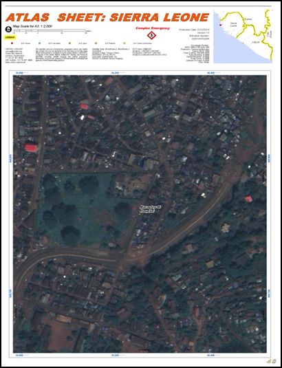
Extract from the UNITAR/UNOSAT atlas featuring the locations of existing and planned Ebola care facilities in West Africa
4.2 Crowd sourced emergency response
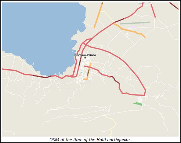
As detailed in Section 2, crowd sourcing has emerged as an innovative approach to emergency management, using satellite data and volunteer mappers from around the world to provide real time data and analysis in response to natural disasters. An example of crowd sourcing of maps and satellite data for emergency response was the 2010 earthquake in Haiti. This is often referenced as the event in which the potential of crowd sourcing as a way to respond to emergencies was established, and where a number of important lessons were learned.
When the magnitude 7.0 earthquake struck Haiti on January 12, 2010, there was an immediate need for maps. Emergency responders had to know where those most in need were located and how to get assistance and relief to them. Given the urgency of relief operations, the ability to crowd-source the data collection and mapping process became particularly important. Volunteers from around the world downloaded satellite images order to trace and record the outlines of streets, buildings, and other places of interest. One important issue that came to light during the efforts to improve user-generated map coverage of Haiti was the duplication of efforts and barriers to combining data sets generated within different applications.
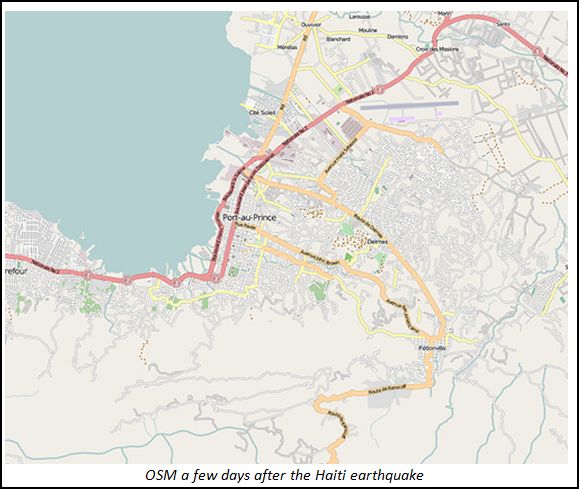
The ability for volunteers to assist in disaster response situations via mapping and other spatial analysis has grown significantly with the development of web-based mapping services. Though there are some concerns about the accuracy of maps created by non-experts, quality assurance systems are being developed and in disaster situations rapidly produced geographic information produced through crowd sourcing with appropriate controls in place is likely to be just as helpful as more traditional mapping in the short term. Crowd sourced disaster response played an integral role in relief efforts in Haiti and in more recent disasters, but as a compliment to rather than a replacement of traditional sources of geospatial information.