
CEOS Disasters Working Group Space agencies organised in the Committee on Earth Observation Satellites (CEOS) formed a permanent Working Group in 2013. Together with volcanologists and Remote Sensing specialists, a Volcano Pilot activity was started with the following aims:
- Demonstrate the utility of integrated, systematic space-based EO as a volcano monitoring tool on a regional basis and for specific case studies
- Provide space-based EO products to the existing operational community (such as volcano observatories and VAACs) that can be used for better understanding volcanic activity and reducing impact and risk from eruptions
- Build the capacity for use of EO data at the majority of the world‘s volcanoes (particularly those that are not monitored by other means)
After further specification, the main objective of the pilot activity consists of a regional study of volcanic unrest and eruptions in the Latin American volcanic arc (from Mexico through to Chile) using radar (SAR) and optical satellite data, to develop methodologies and protocols. The regional demonstration is a precursor to showcase how volcano monitoring would work on a global scale.
About 1500 volcanoes are known to have erupted in the last 12.000 years. Worldwide, about 100 volcanic unrests are observed yearly, and ca. half of them become observable eruptions. It is estimated that less than 10% of active volcanoes are monitored on an on-going basis, meaning that about 90% of potential volcanic hazards are either monitored occasionally, or not at all. Modern space-borne radar satellites provide recognized techniques for the early detection of possible magma injections, for monitoring the stability of volcanoes, and for creating 3D digital elevation models anywhere on Earth. Such techniques provide key information for identifying volcanic hazards and assessing associated risks for human settlements and the environment.
While Space agencies acquire and provide access to space-based imagery, SAR data is analysed to assess deformation of volcanoes, providing insights on the types of data and repeat times best suited to monitoring volcanoes in different environments and supplying deformation information to local users.
- Identification of volcanoes that are in a state of unrest in Latin America and the Lesser Antilles
- Demonstration of the feasibility of operational volcanic monitoring using satellite-based EO
- Tracking of unrest / eruptive activity using satellite data in support of hazards mitigation activities
- Validation of EO-based methodology for improved monitoring of surface deformation
- Improved EO-based monitoring of key parameters for volcanoes that are about to erupt, are erupting, or have just erupted, especially in the developing world
- Capacity-building in countries that do not currently have access to abundant EO data and/or the ability to process and interpret such data
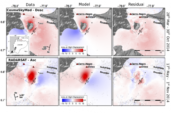
The activity is ongoing. Noteworthy results to date from the Volcano Pilot include: monitoring of the eruption of Calbuco, Chile; monitoring of volcanic unrest in Ecuador and Columbia (Cerro Negro / Chiles), monitoring of deformation of Fernandina, Galapagos; monitoring of post-eruptive inflation of Cordon Caulle, Chile; tracking changes associated with unrest at Cotopaxi, Ecuador, and many more. In all cases, results were either achieved collaboratively with or communicated to, local scientists and stakeholders. Feedback from several local stakeholders confirms the relevance of these results to local decision-making.
References:
Ph. Bally (Ed., 2012): Satellite Earth Observation for Geohazard Risk Management. The Santorini Conference, Santorini, Greece, 21-23 May 2012. (http://esamultimedia.esa.int/docs/EarthObservation/Geohazards/esa-geo-hzrd-2012.pdf)
CEOS (2015): Satellite Earth Observations in Support of Disaster Risk Reduction. The CEOS Earth Observation Handbook. Special 2015 Edition for the 3rd UN World Conference on Disaster Risk Reduction. (http://ceos.org/home-2/eohandbook2015/)
CEOS ad hoc Disasters Team (2013): CEOS Disaster Risk Management Observation Strategy. Issue 2.1. (WGDisasters_DRM-Observation-Strategy_Nov2013.pdf)
Ebmeier, S.K., Elliott, J.R., Nocquet, J.M., Biggs, J., Mothes, P., Jarrín, P., Yépez, M., Aguaiza, S., Lundgren, P. and Samsonov, S.V. (2016): Shallow earthquake inhibits unrest near Chiles–Cerro Negro volcanoes, Ecuador–Colombian border. Earth and Planetary Science Letters, 450.
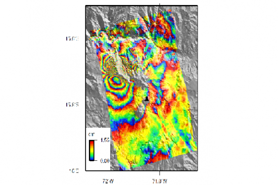
Jay, J. A., F. J. Delgado, J. L. Torres, M. E. Pritchard, O. Macedo, and V. Aguilar (2015): Deformation and seismicity near Sabancaya volcano, southern Peru, from 2002 to 2015. Geophys. Res. Lett., 42, doi:10.1002/2015GL063589.
Poland, M., Zoffoli, S. et al. (2014): CEOS Volcano Pilot Overview. 7 October, 2014
