• English
  • Español
  • Français

United
Nations


Office for Outer Space Affairs
UN-SPIDER Knowledge Portal

  • Inicio
  • Sobre nosotros
    • Sobre ONU-SPIDER
    • Acerca de UNOOSA
    • Publicaciones
    • Ofertas de trabajo
    • Conozca el Equipo
    • Contacto
  • Aplicación Espacial
    • Guías Tecnológicas
    • Mecanismos de Emergencia
    • Mecanismos de Recuperación
    • Red Internacional de Alerta de Asteroides
    • Grupo Asesor para la Planificación de Misiones Espaciales
    • Iniciativa Internacional sobre Meteorología Espacial
    • Tecnologías Espaciales en la ONU
    • Historias de Usuarios
  • Enlaces y Recursos
    • Aplicación de datos del mes
      • Disaster Recovery
    • Fuentes de Datos
    • SIG y Software de Percepción Remota
    • Recursos de capacitación en línea
    • Instituciones
  • Riesgos y Desastres
    • Gestión del Riesgo de Desastres
    • Alerta temprana
    • Gestión de Desastres y Emergencias
    • Amenazas Naturales
    • El Proceso de la Reducción de Desastres Post-2015
    • La ONU y la Gestión del Riesgo de Desastres
    • La ONU y Alerta Temprana
    • La ONU y la Gestión de Desastres
  • Asesoría
    • Misiones de Asesoría
    • Apoyo en caso de Emergencia
    • Asesoría Virtual
    • Prácticas Recomendadas
    • Actividades de Entrenamiento
    • Usos Prácticos
  • Redes
    • Oficinas Regionales de Apoyo
    • GP-STAR
    • IN-MHEWS
    • IWG-SEM
  • Proyectos
    • SPEAR
    • FOSAT-S
    • EvIDENz
    • Flood GUIDE
  • Noticias y Eventos
    • Noticias
    • Eventos
    • Eventos pasados
  • Admin
    • SAM Items

Breadcrumb

  • Home
  • New Research Investigates Early Warning Signals of Anak Krakatau Volcano Collapse
  • New research investigates early warning signals of Anak Krakatau volcano collapse

New research investigates early warning signals of Anak Krakatau volcano collapse

Image: GFZ German Research Centre for Geosciences.Image: GFZ German Research Centre for Geosciences.

On 22 December 2018 a large chunk of the Anak Krakatau volcanic island collapsed into the ocean, causing a tsunami that swept across Indonesia’s Sunda Strait. Because tsunami early warning systems are exclusively equipped to detect tsunamis that are generated by earthquakes, this volcanic collapse-caused tsunami took place without a warning. In the coastal regions of Java and Sumatra, where people were struck off guard, the tsunami killed 400 people and injured many more.

A recent research study published in Nature Communications and led by the German Research Centre for Geosciences (GFZ) has detected deformations in Anak Krakatau leading up to the tsunami that could serve as an early warning system for future volcanic collapses. Satellite data plays a key role in developing such early warning systems by providing monitoring capabilities. As early as late June 2018, the Moderate Resolution Imaging Spectroradiometer (MODIS) instrument on board of NASA’s Terra satellite identified thermal activity in the Anak Krakatau at an intensity not seen since the monitoring began in 2000. This eruptive phase that lasted 175 days added approximately 54 million metric tons of new material to the southern slopes of the volcano, which eventually collapsed into the ocean.

With the use of Interferometric Synthetic Aperture Radar (InSAR), a technique that uses radar pulses from satellites to map the ground, analysis showed that the southern side of the volcano was already slipping towards the ocean at a speed of 4 millimeters per month in the year preceding the collapse. With the increase in eruptive activity in June the flank movement reached 10 millimeters per month, which eventually resulted in the collapse.

The next step in developing an early warning system for future volcanic collapses is to analyze whether these findings apply to different cases as well. If so, satellite-based remote sensing provides yet another tool for disaster risk reduction efforts.
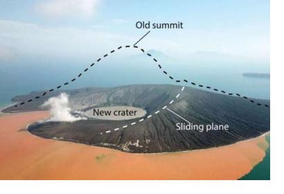
The hazard cascade that led to the Anak Krakatau landslide
Wed, 13 Nov 2019 - 12:13
Asia
Mass Movement
Tsunami
Volcanic Eruption
Terra
TerraSAR-X

Footer menu

  • Contact
  • Terms of Use

User account menu

  • Log in