  • English
  • Español
  • Français

United
Nations


Office for Outer Space Affairs
UN-SPIDER Knowledge Portal

  • Inicio
  • Sobre nosotros
    • Sobre ONU-SPIDER
    • Acerca de UNOOSA
    • Publicaciones
    • Ofertas de trabajo
    • Conozca el Equipo
    • Contacto
  • Aplicación Espacial
    • Guías Tecnológicas
    • Mecanismos de Emergencia
    • Mecanismos de Recuperación
    • Red Internacional de Alerta de Asteroides
    • Grupo Asesor para la Planificación de Misiones Espaciales
    • Iniciativa Internacional sobre Meteorología Espacial
    • Tecnologías Espaciales en la ONU
    • Historias de Usuarios
  • Enlaces y Recursos
    • Aplicación de datos del mes
      • Disaster Recovery
    • Fuentes de Datos
    • SIG y Software de Percepción Remota
    • Recursos de capacitación en línea
    • Instituciones
  • Riesgos y Desastres
    • Gestión del Riesgo de Desastres
    • Alerta temprana
    • Gestión de Desastres y Emergencias
    • Amenazas Naturales
    • El Proceso de la Reducción de Desastres Post-2015
    • La ONU y la Gestión del Riesgo de Desastres
    • La ONU y Alerta Temprana
    • La ONU y la Gestión de Desastres
  • Asesoría
    • Misiones de Asesoría
    • Apoyo en caso de Emergencia
    • Asesoría Virtual
    • Prácticas Recomendadas
    • Actividades de Entrenamiento
    • Usos Prácticos
  • Redes
    • Oficinas Regionales de Apoyo
    • GP-STAR
    • IN-MHEWS
    • IWG-SEM
  • Proyectos
    • SPEAR
    • FOSAT-S
    • EvIDENz
    • Flood GUIDE
    • CommonSpace Initiative
    • Tonga Pilot Project
  • Noticias y Eventos
    • Noticias
    • Eventos
    • Eventos pasados

Breadcrumb

  • Home
  • Recommended Practice: Use of Digital Elevation Data For Storm Surge Coastal Flood Modelling
  • Recommended Practice: Use of Digital Elevation Data for Storm Surge Coastal Flood Modelling

Recommended Practice: Use of Digital Elevation Data for Storm Surge Coastal Flood Modelling

Storm surges and tidal waves are global phenomena that considerably affect human populations in coastal and island regions. According to the Guide to Storm Surge Forecasting published by the World Meteorological Organization in 2011, storm surges can be defined as ‘oscillations of the water level in a coastal or inland body of water in the time range of a few minutes to a few days, resulting from forcing from atmospheric weather systems. According to this definition, the so-called wind waves, which have durations on the order of several seconds, are excluded’. Storm surges are a coastal phenomenon triggered by strong winds in the oceans and seas due to tropical cyclones and other similar weather systems at sea.

In the past tsunami modelling, sea-level rise studies, and storm surge hazard mapping have been done using deterministic and probabilistic models. However, deterministic models require precise oceanographic data, as well as data on bathymetry in the coast, coastal geometry, high-resolution digital elevation models in the coastal area, and ancillary data on surface roughness in coastal areas. In many developing countries these data sets are not easily accessible or available.

Step-by-Step
In Detail

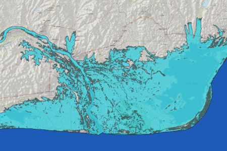
This Recommended Practice allows users to visualize the geographical extent of coastal flooding or sea level rise on a local, regional, or global scale (depending on the resolution and accuracy of the incoming digital elevation model). It can be used exclusively as a first approximation to determine areas that are prone to inundation and can serve as a first assessment for further, more in-depth analysis of coastal flood and sea level rise assessment.

This version of the Recommended Practice is a revision (2024) of the original storm surge RP using the openly accessible and free Copernicus Digital Elevation Model with a resolution of 30 meters. The original version of the RP makes use of the commercial high-resolution (12 m) World Digital Elevation Model (WorldDEMTM) product of Airbus Defence and Space. However, both versions can be used with both datasets, Cop DEM and WorldDEM, but the examples / case studies differ.

For the sake of clarity - the Recommended Practice has not been developed for any other use and purpose than the above described one and is consequently not usable for and in navigation, any hazardous environment requiring error free performance.

Severe Storm
Flood
Preparedness
Larger Accra region, Ghana

The coastal region of Ghana was heavily affected by tidal waves in June 2017. Many people have been displaced and houses, infrastructure and fishing gear (boats, nets) destroyed. This Recommended Practice can be a first assessment to apply further analysis to identify safer ground for relocation of exposed communities. For more information please refer to this link provided by the National Disaster Management Organization of Ghana (NADMO).

ZFL / University of Bonn contact:

For any questions related to the revision of the Recommended Practice and the usage of the COP30 DEM, feel free to get in touch with the author or spokesperson at ZFL:

Josi Bregulla

josi.bregulla@uni-bonn.de    

Michael Schmidt

michaelschmidt@uni-bonn.de

Airbus contact:

For any questions related to Airbus disaster management applications using Earth Observation technology or WorldDEMTM product, feel free to get in touch with the original authors:

Ciro Farinelli

Future SAR Programs Manager, Airbus Defence and Space / Intelligence

ciro.farinelli@airbus.com

Virginia Herrera-Cruz

Application Developer, Airbus Defence and Space / Intelligence

Virginia.herrera@airbus.com

The model can be applied to any coastal region of the world because open-access data was used.

Datos relacionados

view all

Software relacionado

view all

Descargo de responsabilidad:

Por favor tome nota que ni ONU-SPIDER ni las Oficinas Regionales de Apoyo o sus socios se responsabilizan por la calidad de los resultados que se obtienen usando esta práctica recomendad o las decisiones que se tomen con estos resultados.


Footer menu

  • Contact
  • Terms of Use

User account menu

  • Log in