• English
  • Español
  • Français

United
Nations


Office for Outer Space Affairs
UN-SPIDER Knowledge Portal

  • Inicio
  • Sobre nosotros
    • Sobre ONU-SPIDER
    • Acerca de UNOOSA
    • Publicaciones
    • Ofertas de trabajo
    • Conozca el Equipo
    • Contacto
  • Aplicación Espacial
    • Guías Tecnológicas
    • Mecanismos de Emergencia
    • Mecanismos de Recuperación
    • Red Internacional de Alerta de Asteroides
    • Grupo Asesor para la Planificación de Misiones Espaciales
    • Iniciativa Internacional sobre Meteorología Espacial
    • Tecnologías Espaciales en la ONU
    • Historias de Usuarios
  • Enlaces y Recursos
    • Aplicación de datos del mes
      • Disaster Recovery
    • Fuentes de Datos
    • SIG y Software de Percepción Remota
    • Recursos de capacitación en línea
    • Instituciones
  • Riesgos y Desastres
    • Gestión del Riesgo de Desastres
    • Alerta temprana
    • Gestión de Desastres y Emergencias
    • Amenazas Naturales
    • El Proceso de la Reducción de Desastres Post-2015
    • La ONU y la Gestión del Riesgo de Desastres
    • La ONU y Alerta Temprana
    • La ONU y la Gestión de Desastres
  • Asesoría
    • Misiones de Asesoría
    • Apoyo en caso de Emergencia
    • Asesoría Virtual
    • Prácticas Recomendadas
    • Actividades de Entrenamiento
    • Usos Prácticos
  • Redes
    • Oficinas Regionales de Apoyo
    • GP-STAR
    • IN-MHEWS
    • IWG-SEM
  • Proyectos
    • SPEAR
    • FOSAT-S
    • EvIDENz
    • Flood GUIDE
  • Noticias y Eventos
    • Noticias
    • Eventos
    • Eventos pasados
  • Admin
    • SAM Items

Breadcrumb

  • Home
  • Atlas of Cities At Risk From Natural Disasters Published
  • Atlas of cities at risk from natural disasters published

Atlas of cities at risk from natural disasters published

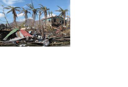
2013 Typhoon Haiyan in Philippines (Image: DFID/ Henry Donati)2013 Typhoon Haiyan in Philippines (Image: DFID/ Henry Donati)

More than 50 percent of the most exposed cities in the world for natural disasters are located in Philippines, China, Japan and Bangladesh, according to a recent publication by the global risk analytics company Verisk Maplecroft.

The 5th annual Natural Hazards Risk Atlas (NHRA) shows that of the 100 cities with the greatest exposure to natural hazards, 21 are located in the Philippines, 16 in China, 11 in Japan and 8 in Bangladesh. The combined risk of tropical storms and cyclones, floods, earthquakes, tsunamis and severe storms or extra-tropical cyclones, among others, has placed the small capital city of Port Vila, on the isolated South Pacific island nation of Vanuatu, on top as the world's riskiest ones.

The Philippines is the most exposed country with eight cities among the ten most risky at global level due to a high risk of tropical storms, earthquakes and landslides. In addition, the country lacks of solid institutional and societal capacity to manage, respond and recover from disasters.

The impact on the economic growth of the exposed countries implies one of the major risks. "Natural hazards constitute one of the most severe disrupters of business and supply chain continuity, and also threaten economic output and growth in some of the world’s key cities, especially for those located in the emerging markets," the report says.   
Verisk Maplecroft
Mon, 9 Mar 2015 - 11:22
Philippines
China
Japan
Vanuatu

Footer menu

  • Contact
  • Terms of Use

User account menu

  • Log in