![]()
United
Nations
Sécheresse
 instrument aboard ESA’s Envisat satellite. Image: ESA, CC BY-SA 3.0 IGO.")
Definition
Facts and figures
Further information
UN-SPIDER Regional Support Offices with hazard-specific expertise
Related content on the Knowledge Portal

A drought/dzud monitoring system known as “DroughtWatch-Mongolia” has been officially handed over to Mongolia on 17 September by the United Nations Economic and Social Commission for Asia and the Pacific (UNESCAP) and the Institute of Remote Sensing and Digital Earth (RADI) of the Chinese Academy of Sciences.
read moreDroughtWatch-Mongolia is a system based on satellite data which aims to provide real-time drought monitoring for disaster prevention and mitigation departments in Mongolia.
Following a request by Mongolia to UNESCAP to pilot its Regional Drought Mechanism, a project entitled, “Strengthening Mongolia's capacity to monitor and warn drought/dzud” was…
02/10/2018 of 2.7 m (i.e., less than one floor) and the share of built-up area could be estimated with a MAE of 13.3 %, when compared to a reference data set.") Publishing institution:
Publishing institution: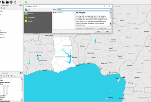
 Satellite based flood mapsPublishing institution:
 ,
,  Publishing institution:
 After the TAM was conducted in Myanmar, innovative impacts were completed following a recommendation. “Emergency Operation Centre (EOC)”, which is comprised of four units including “Remote Sensing Unit” and “Risk Assessment and Emergency Response Unit” was established in the Ministry of Social Welfare, Relief & Resettlement (MSWRR). The capacity building of MSWRR and other related institutes in remote sensing and GIS were strengthened. The Disaster Management Training Centre now conducts courses in remote sensing/GIS. Myanmar has also become the first country in ASEAN to apply for universal access to the International Charter. Myanmar government is aware of the National Spatial Data Infrastructure (NSDI) and one map policy that has been initiated by the Ministry of Education is very crucial.read morePublishing institution:
 ,
, 
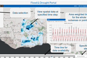
In order to encourage the targeted retrieval of space-based information and data by disaster risk reduction practitioners, content on the Portal is systematically enriched with metadata. For instance, data sources are marked up with data about their file type, satellite/sensor and spatial coverage and whether they relate to the disaster risk management or emergency response phase. The tool features a range of filters that draw on the metadata, thereby allowing users to narrow down their search, for example, filtering available GIS software by hazard type. This ensures that users efficiently find the content that is most relevant to them. At the same time, the Portal encourages the discovery of resources related to those accessed by the user, by providing links to them on the same page. This allows for contextualisation and highlights links between resources…
read morePublishing institution: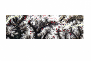 ,
, 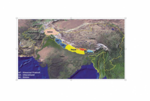
The identification of critical glacial lakes is based on remote sensing method in which several criteria related to glacial lakes, glaciers and physical condition of surrounding area is considered to assess potential for future outburst and possible glacial lake outburst flood (GLOF).
Publishing institution: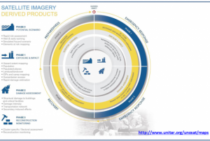 ,
, 
Based on optical and radar images of different resolutions, UNOSAT products are also enriched with the available baseline GIS datasets and crowdsourcing data. Satellite-derived analysis performed by UNOSAT is delivered in the form of GIS Data, Static Maps, Live Web Maps, and Reports, and is then shared with a wide range of end-users such as UN Agencies, International Organizations, and Governments.
Publishing institution: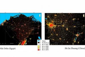 ,
, 
The Global Human Settlement (GHS) framework produces global open source spatial information about the human presence on the planet over time. This is in the form of built up maps, population density maps and settlement maps. This information is generated with evidence-based analytics and knowledge using new spatial data mining technologies. The framework uses heterogeneous data including global archives of fine-scale satellite imagery, census data, and volunteered geographic information. The data is processed fully automatically and generates analytics and knowledge reporting objectively and systematically about the presence of population and built-up infrastructures.
read more
Term Parents
UN-SPIDER Regional Support Offices with hazard-specific expertise
![]()