China Sucessfully Launches New Space Experimental Satellite

On June 20, China successfully launched a new space experimental astellite, Shiyan-25, from the Taiyuan Satellite Launch Center in the northern province of Shanxi. The satellite will mainly be used to conduct new Earth observation technology experiments, covering areas such as disaster prevention and mitigation, urban planning, and land resource surveys.

ZFL Offers Online Training Events on Copernicus Data and Theoretical Background for Floods and Droughts

Floods and droughts are some of the most frequent natural disasters that can become a major threat to livelihoods, food-security, infrastructure and even life. Remote sensing and earth observation provide valuable tools to monitor ongoing floods and drought, assess the current situation from space and produce products that can support stakeholders and decision makers. 

Droughts - Online Training on Copernicus Data and Theoretical Background

This is event is available for participation on an ongoing basis

Doughts are some of the most frequent natural disasters that can become a major threat to livelihoods, food-security, infrastructure and even life. Remote sensing and earth observation provide valuable tools to monitor ongoing floods and drought, assess the current situation from space and produce products that can support stakeholders and decision makers. 

0
0
No certificate issued or not known
0.00
USD
07/04/2023, 12:00am
not visible

Center for Remote Sensing of Land Surfaces (ZFL) of the University of Bonn

1

Floods - Online Training on Copernicus Data and Theoretical Background

This is event is available for participation on an ongoing basis

Floods are some of the most frequent natural disasters that can become a major threat to livelihoods, food-security, infrastructure and even life. Remote sensing and earth observation provide valuable tools to monitor ongoing floods and drought, assess the current situation from space and produce products that can support stakeholders and decision makers. 

0
0
The training is specifically meant for participants from African countries from government agencies, academia, NGOs or other institutions involved in disaster management or risk reduction. 
No certificate issued or not known
0.00
USD
07/04/2023, 12:00am
not visible

Center for Remote Sensing of Land Surfaces (ZFL) of the University of Bonn

1
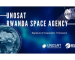
UNOSAT and the Rwanda Space Agency Forge Collaboration in Geo-Information Technologies for Sustainable Development

The United Nations Satellite Centre (UNOSAT) and the Rwanda Space Agency (RSA) finalised a framework cooperation agreement to leverage geo-information technologies for sustainable development. Under the agreement, UNOSAT and the RSA will join efforts in utilising satellite imagery and geospatial data for various purposes, amongst which disaster management, environmental monitoring, urban planning, and sustainable development initiatives.

nuria.alonso Wed, 14 Jun 2023 - 08:40

MOOC on Drought Assessment and Monitoring from Space

This is event is available for participation on an ongoing basis

The MOOC on Drought Assessment and Monitoring from Space (2nd version) has been launched by the EO Africa R&D Facility and will be available online until the end of February 2024.

0
0
Certificate issued

Registration in the EO AFRICA Community is required for this MOOC.

0.00
USD
05/03/2023, 12:00am - 01/28/2024, 12:00am
not visible

Monitoring Water Quality of Inland Lakes using Remote Sensing

This is event is available for participation on an ongoing basis

This advanced-level training will focus on using remote sensing observations from Landsat 8 and 9, Sentinel-2, and Sentinel-3 for assessing water quality parameters, including chlorophyll-a concentration, turbidity, and Total Suspended Solids (TSS) in inland lakes. This training will also highlight the importance of in situ measurements of these parameters, coincident with satellite observations, in developing methodologies for operational water quality monitoring.

0
0
No certificate issued or not known
0.00
USD
07/18/2023, 12:00am - 07/25/2023, 12:00am
not visible
1

Surface Soil Moisture Products at Continental Scale

This is event is available for participation on an ongoing basis

The EO Africa Research & Development Facility is organising the webinar "Surface Soil Moisture products at continental scale", executed by TU Wien, on June 13 at 14:00 CET. 

0
0
No certificate issued or not known
0.00
USD
06/13/2023, 12:00am
not visible