Portugal

country taxonomy block

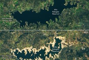
On the Iberian Peninsula Portal and Spain are facing a severe drought, that started in November 2021 and worsened in the following months. Officials in Portugal were forced to limit the use of hydroelectric dams for power production and irrigation, as some reservoirs started reaching significant lows.

The extreme dimension of this event gets revealed on a pair of Landsat 8 OLI (Operational Land Imager) images, operated by NASA and USGS, comparing the state of the Alto Rabagão and Alto Lindoso reservoirs in northern Portugal from March 2021 to February 2022. 

NASA 's earth observatory...

more
Publishing date 21/02/2022

In order to stimulate the use of soon to be available space-based information in the framework of the European Copernicus programme, Portugal created the Working Group for Earth Observation (GTOT). The Group will focus on the implementation of information delivered by the upcoming Sentinel satellites.

The first Sentinel is set to launch in the spring of 2014 and will deliver information on many aspects of the Earth’s environment. It will also provide information to support disaster emergency response. The GTOT in Portugal is assessing the possibilities to incorporate knowledge of processing and analysis satellite imagery within the public administration.

This inter-institutional Group will also conduct an inventory of the Portuguese state regulations on environmental monitoring, civil protection and civil security which may benefit from the Copernicus programme. On this basis, the Group will release an Action Plan for Earth Observation information implementation.

Publishing date 28/01/2014

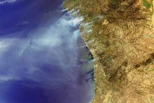
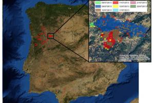
Wildfires remain a serious problem, presenting often-dramatic impacts that can only be minimized through a smart combination of technology, political decision and willingness to accept changes.

Since 1970s satellite remote sensing of fires has become increasingly important, developing various sensors that have been used successfully to detect active fires. In that context, MODIS (Moderate Resolution Imaging Spectroradiometer) is probably the most prominent sensor. Furthermore, nighttime imagery from DMSP-OLS and data from AVHRR (Advanced Very High Resolution Radiometer) have been applied for fire identification. As for prevention efforts, satellite-derived soil moisture information has been used in the context of fire research in an attempt to identify increased pre-event vulnerabilities.

In addition, the International Charter Space and Major Disasters aims to provide a system of space data acquisition and delivery to countries and regions affected by any natural...

more
Publishing date 22/11/2013

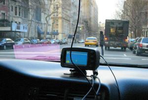
Researchers at Universidad Carlos III de Madrid (UC3M) have developed a new system which improves the ability of a GPS to determine a vehicle's position as compared to that of conventional GPS devices by up to 90 percent, and which can be installed in any vehicle at a very low cost.

The prototype incorporates a conventional GPS signal with those of other sensors (accelerometers and gyroscopes) in order to reduce the margin of error in establishing a location.

The researchers are now starting to work on the integration of this system into a mobile telephone, so that it can integrate all of the measurements that come from its sensors in order to obtain the same result that we have now, but at an even much lower cost, since it is something that almost everyone can carry around in his pocket.

Publishing date 14/02/2013

As the UN marked World Food Day earlier this week, international representatives convened in Korea to discuss ways to curb the loss of productive land to desertification. Satellites play an important role in the monitoring and assessment of drylands.

Desertification is the degradation of land in arid, semi-arid and dry sub-humid areas. It is caused primarily by human activities and climatic variations because dryland ecosystems are extremely vulnerable to over-exploitation, inappropriate land use and droughts.

This phenomenon has severely affected the livelihoods of farmers around the globe, causing food insecurity in many areas. Satellites have the capability to detect desertification and have seen active land degradation trends even in Europe.

Findings were presented at the 10th Conference of the Parties to the UN Convention to Combat Desertification (UNCCD) in Changwon, Korea.

Held 10–21 October, the event gave representatives an opportunity to...

more
Publishing date 24/10/2011

The main goal of this training session is to create theoretical and practical competences on the use of Sentinel data for Land Cover Land Use (LCLU) monitoring (i.e. mapping and change detection) and for forest fires related applications (e.g. fire risk and burned area mapping). This training course is the outcome of the Copernicus Training and Information session which took place in Lisbon on 7 June 2017, where the requirements for hands-on sessions were defined and participants' interest collected.

Preliminary Programme

The course includes lectures on the theory of satellite image processing and classification as well as hands-on exercises.

DAY 1 (Thursday 8 February 2018) - LCLU theory and mapping

Morning:

Theoretical background, principles and methods for land cover mapping. Topics will include:

  • The need for LCLU monitoring
  • Sentinel 2 satellite data
  • Understanding satellite images...
more

Following on from the “15 Years of Progress in Radar Altimetry” Symposium in 2006, and the “20 Years of Progress in Radar Altimetry” Symposium in 2012, both deemed a very successful landmark by the participants and the readership of the Proceedings, we have now reached the 25-year anniversary of the first supply of ERS-1 and TOPEX/Poseidon data products to the Altimetric Community.

To mark this occasion the European Space Agency (ESA), in collaboration with the French Space Agency (CNES), is organising an exceptional Symposium on “25 years of Progress in Radar Altimetry”.

This event will be sponsored by other partner agencies and organisations supporting the development of altimetry.

The workshop brings together European players interested in and actively contributing to the Global Earth Observations System of Systems (GEOSS).

The aim is to look for synergies across projects, initiatives, to offer networking opportunities to the participants and to discuss how Europe can contribute to the international effort.

Objective

The EuroGEOSS initiative was launched in October 2017 during the GEO plenary meeting held in Washington DC. Since then, this regional initiative has been increasingly taking shape. The EuroGEOSS workshop will be a milestone for this initiative and an opportunity to review the latest developments taking place in Europe within EuroGEOSS.

This year's event is dedicated to information with...

more

Save our Ocean, Protect our Future

The Ocean Conference, co-hosted by the Governments of Kenya and Portugal, comes at a critical time as the world is seeking to address many of the deep-rooted problems of our societies laid bare by the COVID-19 pandemic and which will require major structural transformations and common shared solutions that are anchored in the SDGs. To mobilize action, the Conference will seek to propel much needed science-based innovative solutions aimed at starting a new chapter of global ocean action.