![]()
United
Nations
Desplazamiento de masas
 on top of a mountain. It then pushed mud down across the city of Mocoa (green) and crossed the nearby river. The Sentinel-1-derived data product (from scans on 20 March and 1 April) has been overlaid onto a Sentinel-1 radar image. Image: Modified Copernicus")
Definition
Facts and figures
Further information
UN-SPIDER Regional Support Offices with hazard-specific expertise
Related content on the Knowledge Portal

A consortium of Norwegian institutions has used Copernicus Sentinel-1 satellite data in combination with the Interferometric Synthetic Aperture Radar (InSAR) remote sensing technique to map ground movements in the country. The Geological Survey of Norway (NGU), the Norwegian Water Resources and Energy Directorate (NVE) and the Norwegian Space Centre (NSC) make results freely accessible through InSAR Norway, a service launched in November 2018. The service aims to produce ground deformation measurements in the country and improve accessibility of InSAR results for public and commercial users.
How does InSAR imagery work?
InSAR is used in remote sensing and geodesy, the science of measuring the geometric shape of the Earth. It compares two or more...
read more07/03/2019 The Tanzania Commission for Science and Technology (COSTECH), in partnership with the Revolutionary Government of Zanzibar (RGoZ), has launched an initiative to produce detailed aerial imagery maps of the islands of Zanzibar. The cooperative project is called the Zanzibar Mapping Initiative (ZMI). This initiative has drawn global attention because the mapping is done entirely with drones; the ability to map is now available widespread at a local level. The maps produced are of exceptional spatial resolution. Additionally, their free and open source data sets includes a comprehensive compilation of available vector and raster data covering the whole of Tanzania. Users can find not only aerial imagery produced from drones, but everything from census data to land use layers.
More information can be found on the ZMI project website: http://www.zanzibarmapping.com/Publishing institution: The Global Landslide Catalog (GLC) was developed with the goal of identifying rainfall-triggered landslide events around the world, regardless of size, impacts or location. The GLC considers all types of mass movements triggered by rainfall, which have been reported in the media, disaster databases, scientific reports, or other sources. The GLC has been compiled since 2007 at NASA Goddard Space Flight Center.Publishing institution:
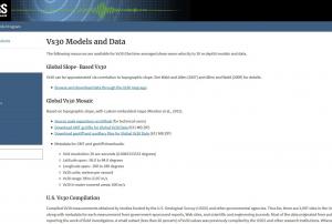 Compiled Vs30 measurements obtained by studies funded by the U.S. Geological Survey (USGS) and other governmental agencies. Thus far, there are 2,997 sites in the United States, along with metadata for each measurement from government-sponsored reports, Web sites, and scientific and engineering journals. Most of the data originated from publications directly reporting the work of field investigators. A small subset (less than 20 percent) of Vs30 values was previously compiled by the USGS and other research institutions. Whenever possible, Vs30 originating from these earlier compilations were crosschecked against published reports.
Both downhole and surface-based Vs30 estimates are represented. Most of the VS30 data are for sites in the western contiguous United States (2,141 sites), whereas 786 Vs30 values are for sites in the Central and Eastern United States; 70 values are for sites in other parts of the United States, including Alaska (15 sites), Hawaii (30 sites),...Publishing institution: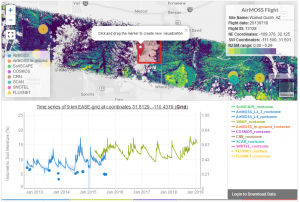 Publishing institution:
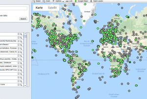 Movebank is a free, online database of animal tracking data hosted by the Max Planck Institute for Ornithology. The institute help animal tracking researchers to manage, share, protect, analyze, and archive their data. The animal tracking data in Movebank belongs to researchers all over the world who choose whether and how to share their data with the public. Curretnr esearch is being done on animal derived early warning systems for earthquakes, volcanoes and landslides.Publishing institution:
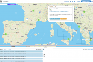 ESA's Earth Observation Thematic Exploitation Platform (TEP) is a browser for satellite imagery and specific products on an environmental topic. The TEP platforms are divided into 7 categories: Coastal; Forstry; Geohazards; Hydrology; Polar; Urban; and Food Security. Each platform is a collaborative, virtual work environment providing access to EO data and the tools, processors and Information and Communication Technology resources required to work with them. TEP aims to bridge the gap between the users and the data and tools.Publishing institution:
 Pleidas, TerraSar-X, SPOT and Elevation data available commercially from airbus, certain sample data sets at various locations available for free.Publishing institution:
 The website: https://www.radiant.earth
Help and Tutorials: https://help.radiant.earth/
Demos & Use Cases: https://demos.radiant.earth/Publishing institution: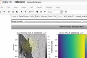
Welcome to the fascinating world of Radar tomography. This tutorial presents a set of training resources for the introduction into this advanced Radar remote sensing technique. The material consists of the following components
A theory unit comprising Slides on Basics, Concepts & Techniques
An interactive Python tutorial including a Jupyter Notebook
Free Test data from the airborne F-SAR platform
An explanation video on how to use the tutorialThe module SAR Tomography introduces the advanced technique of combining multiple radar images from several viewing angles into a new dimension of information. Although tomogoraphic measuring systems and applications are recently in an experimental stage, this technology has a large potential to enhance the information content of radar data. This module gives an overview of the basics, limitations, mathematical foundations, advanced techniques and recent case studies.
Related...
read more
Term Parents
UN-SPIDER Regional Support Offices with hazard-specific expertise
![]()