, processed by ESA.")
Space technologies and geospatial data can support governments in improving situational awareness and responding to the COVID-19 outbreak. Several institutions have published information products, such as web maps of confirmed infections and deaths, that are making use of the advantages of GIS. Others have used space technologies to track pollution levels across the world, highlighting a drop due to the restrictions imposed as a result of the pandemic. Yet others are using a combination of global navigation satellite systems technologies to map the position of critical infrastructure in geographical areas where there are reported cases.

The United Nations Office for Outer Space Affairs, through its UN-SPIDER programme, has created this COVID-19 emergency response overview page to facilitate the discovery of examples of contributions of space technologies to addressing COVID-19 that are being published by government agencies, international and regional organizations, academia, civil society and the private sector. To find out more about the efforts of UNOOSA in advancing the use of space-based solutions for global health, please visit this web page.
To support users in finding relevant content, the list below can be filtered by keywords as well as format of the resource. The list does not seek to be exhaustive, nor to recommend particular sources, but to provide a selection of examples of how space technologies and the space community support response efforts to COVID-19.
UNOOSA will host a webinar on Space4Health on 14 May at 10am and 4pm Vienna, Austria time (UTC+2).
If you are using space technologies for responding to the COVID-19 pandemic and would like your work to be included on this page, please use this form to submit details.
With the new NASA @ WORK opportunity, NASA is seeking additional viable solutions where the agency can make a meaningful difference. For the initial call for ideas, NASA leadership, working with the White House and other government agencies, determined three focus areas around personal protective equipment, ventilation devices, and monitoring... Read more
Tag: Situational data, Risk assessments, Emergency mapping, (Indirect) impact of the virus
On 30-31 May, NASA, along with the European Space Agency (ESA) and the Japan Aerospace Exploration Agency (JAXA), are inviting coders, entrepreneurs, scientists, designers, storytellers, makers, builders, artists, and technologists to participate in a virtual hackathon. During a period of 48 hours, participants from around the world will create... Read more
Tag: Situational data, Emergency mapping, (Indirect) impact of the virus, Research opportunities

The NASA Jet Propulsion Laboratory has developed a low-cost respirator design called VITAL (Ventilator Intervention Technology Accessible Locally) that would help critically ill COVID-19 patients and bolster scarce stocks of traditional hospital ventilators. The prototype is composed of far fewer parts than traditional ventilators and is... Read more
Tag: Situational data, Tele-health
Preventative measures recently adopted to prevent further spread of COVID-19 in the United States of America have prompted an overall slowdown in economic activity and fewer vehicles on the roadways. Since combustion engine powered vehicles can represent a major source of nitrogen dioxide (NO2) emissions, less traffic on the roadways may lead... Read more
Tag: (Indirect) impact of the virus

An article from the National Aeronautics and Space Administration (NASA) discusses how images of Earth at night show lights of cities, highways, and other infrastructure that are fingerprints of how civilization has spread across the planet. A team of scientists from NASA’s Goddard Space Flight Center (GSFC) and Universities Space... Read more
Tag: (Indirect) impact of the virus

Maxar's Open Data Programme has released an initial set of high-resolution satellite imagery in support of the COVID-19 response efforts. Per requests from their humanitarian partners, this release will include their Metro imagery basemaps for the following African cities: Addis Ababa, Abidjan, Dakar, Lagos, Kano, Ibadan, Ouagadougou, Accra... Read more
, Map
Tag: Emergency mapping
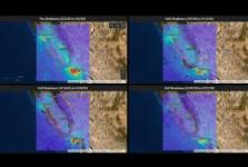
The coronavirus pandemic constitutes an unprecedented challenge with severe societal and socio-economic consequences. In order to shed new light on these changes taking place, ESA and the European Commission have worked closely together to create the "Rapid Action Coronavirus Earth... Read more
, Map
Tag: Situational data, (Indirect) impact of the virus
NASA's Earth Science Division (ESD) calls the attention of the Earth Science research, applications, and data systems communities to Program Element A.28 "Rapid Response and Novel Research in Earth Science" (RRNES) of Research Opportunities in Space and Earth Sciences (ROSES) 2020 as an opportunity to propose investigations making... Read more
Tag: Research opportunities

Maintained by the Coordination Center for the Prevention of Natural Disasters in Central America (CEPREDENAC) of the Central American Integration System (SICA), the Information and Coordination Platform for the Emergency: SICA COVID-19 shows the number of confirmed COVID-19 infections, deaths and recoveries in Central America and the Dominican... Read more
Tag: Situational data

A group of researchers from Johns Hopkins University is studying the link between weather and COVID-19 cases. The team is using information about precipitation from the Global Precipitation Measurement mission, temperature from the MODIS instrument, and soil moisture and water cycle from NASA’s Soil Moisture Active Passive mission (SMAP)... Read more
Tag: (Indirect) impact of the virus
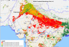
Major agricultural economies are among countries putting in place social distancing and lockdown measures to try contain the outbreak. However, these measures are having a negative impact on food production.
Satellite technology can efficiently help with agricultural planning. Satellite data can help ease travel restrictions to... Read more
, Web page
Tag: (Indirect) impact of the virus
The article highlights how space technologies help monitor food supply chaines during the COVID-19 pandemic.
Tag: (Indirect) impact of the virus