Natural disasters often cause severe damage to critical infrastructure, resulting in widespread power outages. Satellite-observed night-time light data has become a crucial tool to evaluate these disruptions and assess progress toward Sustainable Development Goals (SDGs) 11 and 13. However, daily night-time light time series often suffer from high uncertainty and fluctuations caused by the satellite's viewing zenith angle (VZA).
To address this, this Recommended Practice introduces a highly generalizable angular normalization algorithm to process VIIRS daily night-time light data. A key advantage of this universal method is its ability to effectively remove the angular effect during various disaster assessments, regardless of the specific hazard or geographic location. By mitigating these viewing angle fluctuations, the method generates a highly stable time series that accurately captures the abrupt decline in lighting after a disaster and the subsequent recovery process, allowing for a reliable estimation of power outages and proxy economic losses.
The objective of this practice is to accurately identify the extent of power loss and monitor the chronological power restoration process in disaster-affected regions. This information can be used by government authorities, disaster management agencies, and humanitarian organizations to guide timely rescue efforts, allocate relief resources, and evaluate long-term infrastructure resilience.
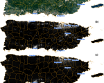
The Recommended Practice was initially applied to power outages caused by Hurricane Maria in Puerto Rico (2017) using daily night-time light data, and was subsequently utilized to assess the 2023 Kahramanmaraş Earthquake in Turkey and the 2023 Monsoon Floods in Pakistan. The disaster impacts were extracted from VIIRS Black Marble products (VNP46A1/A2) by utilizing an angular normalization algorithm and the Prophet model to ensure temporal continuity. Power disruption and recovery trajectories were assessed by calculating the Power Supply Index (PSI) and Power Restoration Index (PRI), which were further correlated to estimate regional GDP loss rates. The analysis specifically targets urban built-up areas extracted from 30-meter GlobeLand30 data and works best for regions with established electrical infrastructure.
Related Data:
VIIRS Daily Black Marble Product Suite (NASA)
GlobeLand30 Land Cover Dataset (National Geomatics Center of China, NGCC)
Wuhan University contact:
Dr. Xi Li Professor, State Key Laboratory of Information Engineering in Surveying, Mapping and Remote Sensing , Wuhan University
This practice can be applied to evaluate power outages caused by sudden natural disasters globally. Because the methodology relies on tracking changes in artificial light emissions, it works best in urban built-up areas with concentrated populations and established electrical infrastructure.
This is event is available for participation on an ongoing basis
United Nations-Pakistan International Conference on Leveraging Space Technology for Early Warning for All (EW4All), Climate Action and Disaster Risk Assessment, and International Training Course on Space based Disaster Management - Shifting Focus from Reactive to Proactive Approaches
Islamabad, Pakistan, 27 October - 7 November 2026
Hosted by the Pakistan Space and Upper Atmosphere Research Commission (SUPARCO) on behalf of the Government of Pakistan
Regional Symposium and Training on Space Technologies for Humanity in Nairobi
From 16–20 February 2026, the Regional Symposium on Space Technologies for Humanity (16–17 February) was held in Nairobi, followed by a Regional Training on the International Charter.
Tropical Cyclone Gezani made landfall on Madagascar’s eastern coast on 10 February 2026, striking the port city of Toamasina with maximum sustained winds of 211 km/h. The system, which formed in the Southwest Indian Ocean on 6 February, passed north of Mauritius and Reunion before intensifying into a Category 4 equivalent cyclone prior to impact. This follows the devastating passage of Cyclone Fytia, which affected the island just ten days earlier, claiming 14 lives and impacting over 85,000 people.
Tropical Cyclone Fytia made landfall on Madagascar's western coast on 31 January 2026, bringing heavy rainfall, strong winds, and storm surges to some of the country's most remote regions. Preliminary assessments indicate significant humanitarian impacts across central and northern areas, with tens of thousands of people potentially affected.
Heavy rains since mid-December have caused widespread flooding across Mozambique, particularly in the provinces of Gaza, Maputo, and Sofala. Several major river basins have risen above alert levels, leading to extensive inundation, displacement, and damage to communities as floodwaters persist and rainfall continues.
Tropical forests, often described as the planet’s “green lungs,” absorb vast quantities of carbon dioxide, release oxygen, and play a crucial role in regulating Earth’s climate. While widespread deforestation has long been recognised as a major threat, new research identifies a less obvious but highly significant driver of carbon emissions: small-scale forest clearing. Surprisingly, the removal of relatively small forest patches is responsible for more than half of net carbon losses across the tropical regions.


")


