Greece

country taxonomy block

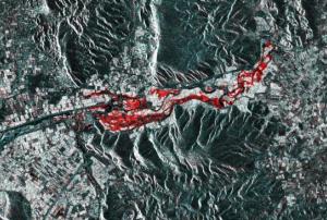
Greek Geographic Information Systems company Geospatial Enabling Technologies (GET) has tested a new crisis management solution based on services rendered through the Copernicus Sentinel Hub after flooding in Farkadona, Greece.

The Copernicus Sentinel Hub, set up by the European Commission and European Space Agency, is a service that provides quick and up-to-date satellite information to be used by authorities. Through the Sentinel-1 satellite in particular, they use radar to track differences between flooded and dry land through before and after images.

In late February, flooding and landslides caused by heavy rainfall affected the Farkadona municipality in central Greece, leading to evacuations and loss of farmland in the region. In response, GET used imagery produced by the Sentinel-1 satellite in a prototypical algorithm that uses the Sentinel…

more
Publishing date 30/04/2018

 The Institute for Astronomy, Astrophysics, Space Applications and Remote Sensing (IAASARS), one of the three institutes of the National Observatory…

more
Publishing date 04/06/2016
Regional Support Offices mentioned:

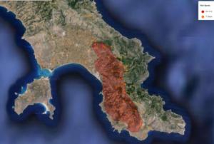
The European Forest Fire Information System (EFFIS) has helped bringing under control the forest fires that affected Greece on July 17. The EU Emergency Response Coordination Centre (ERCC) used EFFIS to mitigate the effects of the wildfires after Greece activated the EU Civil Protection Mechanism.

Immediately following the activation, France sent two Canadair firefighting planes and a reconnaissance aircraft to combat the almost 80 separate wildfires in Greece, located from the island of Evia, northeast of Athens, to the southern Peloponnese. This reaction was based on the agreement of cooperation in disaster response among 33 European states coordinated by the EU Civil Protection Mechanism, managed by the European Commission through the ERCC.

The ERCC is on charge of monitoring large fires occurring in Europe through satellite imagery and tools such as EFFIS, which provides information of the damaging effects of fires in near real-time and fire danger forecast…

more
Publishing date 23/07/2015

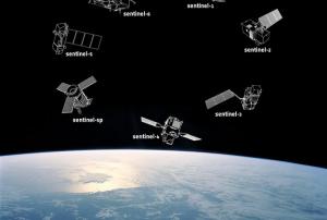
The European Space Agency (ESA) and Greece signed an arrangement that establishes access to Sentinel data. As UN-SPIDER reported, Sentinel-1A is already delivering images, providing different environmental information.

The Sentinel missions will provide information for various application areas – emergency response, disaster management and environmental monitoring. Greece and ESA now signed an Understanding for a Collaborative Ground Segment Cooperation. The National Observatory of Athens (NOA) intends to create a “national mirror site” as a platform for information and processed image exchange.

“The objective of this activity is to provide data for priority national activities with a prospect to serve the needs of transnational cooperations between Greece and neighbouring southeastern Mediterranean and Balkan countries, as well as the…

more
Publishing date 13/05/2014

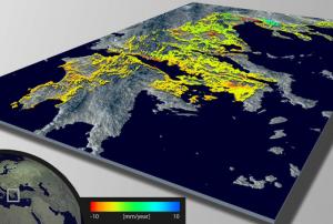
The European Space Agency ESA has developed a new Wide Area Processor, or WAP. The data processor can create maps of land deformation from satellite radar data over larger areas and with higher precision than ever before. These maps can be used to detect and monitor geological hazards.

Factors like mining, earthquakes or volcanoes can make the ground sink or rise. In order to measure these changes, radars on satellites can map the changes on a global scale and with millimetre-precision.

ESA explains how the new processor works: "WAP has been developed to process the full radar data over a specific area automatically and then mosaic adjacent datastacks with uniform quality, yielding country-sized maps of land deformation with unprecedented accuracy."

"To do this, the WAP applies the remote sensing technique ‘persistent scatterer interferometry’. Persistent scatterers are stable objects that reflect radar well, such as metal structures and buildings, and are…

more
Publishing date 01/05/2013

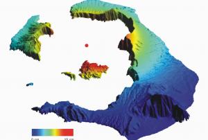
Over the past year and a half, parts of the Greek Santorini islands have risen by 14 cm. Scientists believe that new molten rock has been squeezing up beneath a volcano accumulating in a magma chamber at a depth of about 4 km. Satellite data confirm that the islands have risen as much as 14 cm since January 2011. The Santorini volcano’s last major explosive eruption was about 3600 years ago. In a study published this week in Nature Geoscience, the team discovered that the whole island group has been inflating – slowly rising and moving outward – almost systematically.

To map the movement, the scientists used radar data from ESA’s Envisat satellite from March to December 2011 and from the German TerraSAR-X mission from July 2011 to April 2012. To ensure accurate measurement, the team also used GPS receivers and an island-wide network of triangulation stations. The study outlines that the total amount of vertical movement is now approaching 8–14…

more
Publishing date 10/09/2012

"eurisy" is announcing a workshop for Local and regional authorities using satellite services to understand, mitigate and adapt to climate change on 19-20 November 2009, Athens, Greece

Satellites have had a unique and substantial contribution to identifying and recognising climate change. Today, they offer unrivalled, innovative tools for climate change mitigation and adaptation on a local level.This workshop will inform local and regional authorities, SMEs and other potential users of satellite information and services of how they can better tackle climate change by using these tools.Good practice presentations will be the starting point of discussions about how such actors can finance and implement these innovative tools. (Source: eurisy)

For more information: http://www.eurisy.org/

more
Publishing date 30/07/2009

The Geomapplica 2018 International Conference is an international event, aiming to present ongoing research activities and advances at the various applications of Geomatics, Remote Sensing and GIS Applications.  The conference will explore the use of Geospatial Data in providing solutions to real-world problems. New forms of data like LIDAR imagery & UAV Photography are being used in the quest for results on applied problems. More sophisticated processing techniques are developed in photogrammetry and the uses of GISs are converging to imagery. Topics include using Geospatial Data for sustainable development, environmental and natural resource management, coastal & marine and disaster management.

Humans experience a wide array of disasters that generally fall into two categories: natural disasterssuch as hurricanes, earthquakes, tsunamis, volcanic eruptions, etc., and unnatural, or man-made, disasters such as wars, explosions, wildfires, chemical spills, etc. Such disasters wreak havoc and provoke extensive and large-scale devastation, and carry extremely serious financial repercussions for nations, organizations, and individuals.

The study of dynamics of disasters is an important and worthwhile endeavour, with huge benefits for everyone. The DOD 2019 Conference aims to bring together experts in order to share the latest findings on natural and unnatural disasters. 

Machine Learning plays a pivotal role in the Dynamics of Disasters. Click here to view the Machine Learning tutorial for DOD 2019.