![]()
United
Nations
Flood
, processed by ESA, CC BY-SA 3.0 IGO.")
Definition
Facts and figures
Further information
UN-SPIDER Regional Support Offices with hazard-specific expertise
Related content on the Knowledge Portal

The training date is in the past. However, videos and resources of the training can be accessed here.
According to the UNDP, by 2050, two thirds of the world’s population is likely to live in cities. Urban flooding is already a major risk for cities. Increasing impervious surface area, inadequate storm water drainage, and aging infrastructure all contribute. As a result, growing urban populations will face a greater risk of flooding from extreme weather events. This webinar series will focus on the components of urban flooding that satellite data can track:
- Extreme precipitation
- Flooding
- Waterlogged and ponded surfaces
Using satellite data allows individuals and organizations to develop better plans for handling floods. This can include developing better early warning…
read more
The training date is in the past. However, videos and resources of the training can be accessed here.
Optical satellite remote sensing depends on cloudless, well-illuminated areas to produce quality data. This is especially problematic for collecting data during nighttime or when there is cloud cover. Radar is an ideal sensor because of its ability to “see” the surface through clouds or regardless of day or night conditions. In addition, the radar signal can penetrate through the vegetation canopy and provide information about conditions underneath, such as whether there is flooding. Also, techniques such as interferometry can track surface deformation on the order of centimeters, such as displacement caused by earthquakes.
This webinar series builds on ARSET's previous webinar,…
read more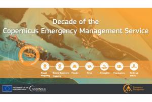
Implementing science to save lives: A Decade of the Copernicus Emergency Management Service
The Copernicus Emergency Management Service (CEMS) celebrates a decade of operation as a world leader in emergency mapping, early warning tools and open-access disaster information.
For the past ten years, CEMS has provided a global service as a fully operation emergency mapping service at no cost to users and with open access data.
Some highlights on the contribution of CEMS in global disaster risk management activities:
- 576 Rapid Mapping Activations with 5,500+ maps delivered
- Designed and implemented the world’s first Global Flood Monitoring tool
- Ten years of wildfire forecasts up to ten days into the future
- Average of 200+ flood and 500+ flash flood notifications to Member States and authorised users each year
- Offers a current and historical database of 7,000+ drought episodes since 1950
…
read more22/06/2022 Publishing institution:
-
Publishing institution:
On 10 May 2022, the United Nations Office for Outer Space Affairs (UNOOSA), the University of Energy and Natural Resources of Ghana, and the Prince Sultan Bin Abdulaziz International Prize for Water (PSIPW) inaugurated the 5th International Conference on the Use of Space Technology for Water Resources Management. The conference, held in Accra from 10 to 13 May 2022, aims to promote the use of space technology in water management in developing countries.
During the opening segment of the conference, high ranking authorities noted that there have been many success stories related to the Sustainable Development Goals (SDGs), but unfortunately some of these were eroded by the COVID 19 pandemic. They remarked that Ghana is hosting this conference to see how best to foster new partnerships to address the SDGs, and to facilitate a constructive discussion on two key issues essential to sustainable development: Space technologies and sustainable use of water…
read more12/06/2022
On 11.03.2022, Tropical Cyclone Gombe led to extensive flood events in northern and central Mozambique.
More information here: https://floodlist.com/africa/mozambique-cyclone-gombe-march-2022
Preliminary impacts reported by INGD indicate that many houses and power lines have been destroyed or damaged; twelve people have been reported killed, several have been injured, and overall more than thirty thousand people have been affected. There are also over one hundred schools damaged or destroyed, one bridge has collapsed, and several roads have been affected.
As a consequence, Copernicus EMS and the International Charter Space and Major Disasters, making use of the potential of space-based technologies for emergency mechanisms, were active. Below, you find a collection of links to the activations…
read more18/03/2022 Publishing institution:
-
Publishing institution:
 Publishing institution:
Term Parents
UN-SPIDER Regional Support Offices with hazard-specific expertise
![]()