  • English
  • Español
  • Français

United
Nations


Office for Outer Space Affairs
UN-SPIDER Knowledge Portal

  • Home
  • About Us
    • What is UN-SPIDER?
    • About UNOOSA
    • Publications
    • Jobs
    • Meet the Team
    • Contact
  • Space Application
    • Satellite Technology
    • Emergency Mechanisms
    • Recovery Mechanisms
    • International Asteroid Warning Network
    • Space Mission Planning Advisory Group
    • International Space Weather Initiative
    • Space Technologies in the UN
    • User Stories
  • Links & Resources
    • Data Applications
      • Disaster Recovery
    • Data Sources
    • GIS and Remote Sensing Software
    • Online Learning Resources
    • Institutions
  • Risks & Disasters
    • Disaster Risk Management
    • Early Warning Systems
    • Emergency and Disaster Management
    • Natural Hazards
    • Sendai Framework
    • The UN and Disaster Risk Management
    • The UN and Early Warning
    • The UN and Disaster Management
  • Advisory Support
    • Advisory Missions
    • Emergency Support
    • Virtual Advisory Support
    • Recommended Practices
    • Training Activities
    • Practical Uses
  • Network
    • Regional Support Offices
    • GP-STAR
    • MHEWS
    • IWG-SEM
  • Projects
    • SPEAR
    • SEWS-D
    • EvIDENz
    • Flood GUIDE
  • News & Events
    • News
    • Events Calendar
    • UN-SPIDER Events Archive

Breadcrumb

  • Home
  • Taxonomy Pages
  • Taxonomy Pages

Pollution

UN-SPIDER Regional Support Offices with hazard-specific expertise

Title: ERATOSTHENES Centre of Excellence

Related content on the Knowledge Portal

  • ISS-SERVIR Environmental Research and Visualization System (ISERV)
    Publishing institution:
    1. SERVIR
  • Data Discovery Portal (WASCAL)
    Publishing institution:
    1. West African Science Service Center on Climate Change and Adapted Land Use (WASCAL)
  • Climate Data Online (NOAA)
    Publishing institution:
    1. National Oceanic and Atmospheric Administration (NOAA)
  • Environmental Response Management Application (ERMA - NOAA)
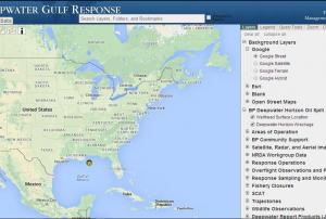
    ERMA® is an online mapping tool that integrates both static and real-time data, such as Environmental Sensitivity Index (ESI) maps, ship locations, weather, and ocean currents, in a centralized, easy-to-use format for environmental responders and decision makers
    Publishing institution:
    1. National Oceanic and Atmospheric Administration (NOAA)
  • Global Land Cover Facility (University of Maryland, NASA, GOFC-GOLD)
    Publishing institution:
    1. University of Maryland
  • TerraSAR-X (DLR)
    Screenshot of TerraSAR-X (DLR)
    Publishing institution:
    1. German Aerospace Center (DLR)
  • Very high resolution optical satellite imagery (Digital Globe)
    Publishing institution:
    1. DigitalGlobe
  • Earth System Data and Information Services Center (GES DISC - NASA)
    Publishing institution:
    1. National Aeronautics and Space Administration (NASA)
  • Global Elevation (ISCGM)
    Publishing institution:
    1. International Steering Committee for Global Mapping (ISCGM)
  • Multi-hazard profile of Sri Lanka (UNDRR)
    Ground-based Information
    Publishing institution:
    1. United Nations Office for Disaster Risk Reduction (UNDRR)

Pagination

  • First page « First
  • Previous page ‹ Previous
  • …
  • Page 5
  • Page 6
  • Page 7
  • Page 8
  • Current page 9
  • Page 10
  • Page 11
  • Page 12
  • Page 13
  • Next page Next ›
  • Last page Last »

UN-SPIDER Regional Support Offices with hazard-specific expertise

Title: ERATOSTHENES Centre of Excellence

Footer menu

  • Contact
  • Terms of Use

User account menu

  • Log in