![]()
United
Nations
Incendio
, processed by ESA, CC BY-SA 3.0 IGO.")
Definition
Facts and figures
Further information
UN-SPIDER Regional Support Offices with hazard-specific expertise
Related content on the Knowledge Portal
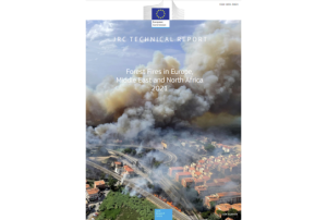
Excerpt from Press Release of the European Commission on 31 October 2022
European Forest Fire report: Three of the worst fire seasons on record took place in the last six years
The European Commission’s Joint Research Centre (JRC) published the latest edition of its Annual Report on Forest Fires in Europe, the Middle East and North Africa in 2021. It concludes that last year's fire season was the second worst in the EU territory in terms of burnt area (since records began in 2006), after 2017 when over 10,000 km² had burnt. More than 5,500 km² of land burnt in 2021 – more than twice the size of Luxembourg – with over 1,000 km² burnt within protected Natura 2000 areas, the EU's reservoir of biodiversity.
The report does not yet cover this year's fires, which have been even more destructive than the ones in 2021. The annual reports allow having past fire seasons as a...
read more10/11/2022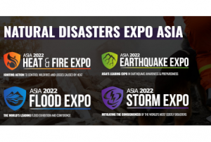
Consists of:
- Heat and Fire Expo Asia
- "The Heat and Fire Expo Asia is the innovative exhibition and conference designed to support the mitigation for one of the most costly natural disasters in the World by showcasing the latest revolutionary global solutions."
- Earthquake Expo Asia
- "The Earthquake Expo Singapore is the most innovative exhibition and conference dedicated to supporting the mitigation of one of the world’s most devastating natural disasters."
- Flood Expo Asia
- "The Flood Expo Asia is the ultimate innovative exhibition and conference designed specifically to support the mitigation of the most costly natural disasters in the region, by showcasing the global solutions available today that will...
- Heat and Fire Expo Asia
Consists of:
- Heat & Fire Expo
- "The Heat & Fire USA is the leading wildfire prep, management, and recovery event, showcasing the latest tools, strategies, and insights among investment and global industry leaders."
- Earthquake Expo
- "The Earthquake Expo USA is the leading seismic prep, management, and recovery event, showcasing the latest tools, strategies, and insights among investment and global industry leaders."
- Flood Expo
- "The Flood Expo USA is the leading flood prep, management, and recovery event, showcasing the latest tools, strategies, and insights among investment and global industry leaders."
- ...
- Heat & Fire Expo
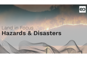
Text adapted from https://eo-college.org
Welcome to the ‘Hazards and Disasters’ online courses. In the three MOOCs which are part of it, we will take a closer look at how remote sensing can answer essential questions related to the emergency response that is needed during hazardous events. Thus, disaster management heavily relies on remotely sensed data and their prompt processing in order to support decisions that can a) estimate the extent of a (natural) disaster and b) save lives by scientifically justifiable choices.
In the three lessons of this course, we will present different applications of remotely sensed data for disaster monitoring to you. At first, we will take a look at droughts, then dive into mapping flood extents using an interactive cloud-based approach before ending our course with the monitoring of fire hazards.
In the lessons listed below, you will be doing the...
read more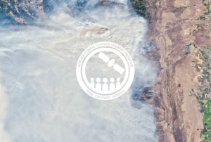
The training date is in the past. However, videos and resources of the training can be accessed here.
Fires are a growing concern, especially in regions with longer fire seasons, expanded wildland/urban interfaces, and severe and frequent droughts. Anthropogenic fires are commonly used to clear grassland and agricultural land prior to the planting season, and forests are often cleared using fires so the land can be repurposed for other uses. Whether naturally-occurring or anthropogenic, fires produce a significant change in the structure and reflectance of vegetation and soil properties and atmospheric chemistry. Remote sensing can be used to monitor pre-, during-, and post-fire conditions; including weather and climate conditions, fuel characterization, fire risk, smoke detection, monitoring, and forecasting,...
read more
The training date is in the past. However, videos and resources of the training can be accessed here.
Record breaking fire seasons, like those we saw in California in 2020, demonstrate how climate change influences the risk and severity of fires on a global scale. Climate change impacts can increase fire frequency, disrupt historical fire regimes, and contribute to increases in fire intensity and burn severity. Therefore, assessments of fire risk and post-fire mapping and monitoring are vital for effective management and decision-making. This training will consist of two sessions with hands-on-exercises and “lab time,” where participants will complete exercises with instructors online to answer questions as they come up. During the first session, we will review pre-fire risk assessment by investigating land surface...
read more
The training date is in the past. However, videos and resources of the training can be accessed here.
With more frequent and severe droughts, certain areas are experiencing longer fire seasons. Wildfire detection, monitoring, and mitigation is increasingly important in these regions. Satellite remote sensing data is useful for identifying active fires, evaluating burned areas, and assessing fire emissions. This advanced training will highlight tools useful for local fire managers. Presentations and exercises will introduce participants to tools to identify active fires, visualize fire emissions, and calculate burn severity.
By the end of the training, attendees will be able to:
- Identify active fires, visualize fire emissions, and calculate burn severity
- Use the QGIS FMT to enter fire...
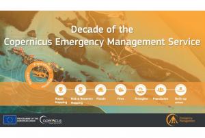
Implementing science to save lives: A Decade of the Copernicus Emergency Management Service
The Copernicus Emergency Management Service (CEMS) celebrates a decade of operation as a world leader in emergency mapping, early warning tools and open-access disaster information.
For the past ten years, CEMS has provided a global service as a fully operation emergency mapping service at no cost to users and with open access data.
Some highlights on the contribution of CEMS in global disaster risk management activities:
- 576 Rapid Mapping Activations with 5,500+ maps delivered
- Designed and implemented the world’s first Global Flood Monitoring tool
- Ten years of wildfire forecasts up to ten days into the future
- Average of 200+ flood and 500+ flash flood notifications to Member States and authorised users each year
- Offers a current and historical database of 7,000+ drought episodes since 1950
...
read more22/06/2022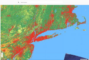 Publishing institution:
-
Publishing institution:
Term Parents
UN-SPIDER Regional Support Offices with hazard-specific expertise
![]()