![]()
United
Nations
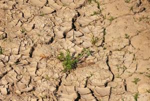
Sequía
 instrument aboard ESA’s Envisat satellite. Image: ESA, CC BY-SA 3.0 IGO.")
Definition
Facts and figures
Further information
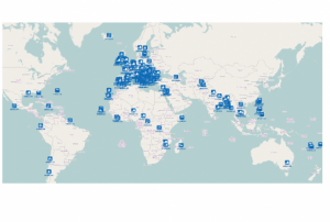
UN-SPIDER Regional Support Offices with hazard-specific expertise
Related content on the Knowledge Portal
 of 2.7 m (i.e., less than one floor) and the share of built-up area could be estimated with a MAE of 13.3 %, when compared to a reference data set.")
Mapping of built-up height and share of built-up area for the example of the city of Munich. The estimated average built-up height features a mean absolute error (MAE) of 2.7 m (i.e., less than one floor) and the share of built-up area could be estimated with an MAE of 13.3 %, when compared to a reference data set.
Publishing institution:") ,
, ") ,
, ")
For a comprehensive and objective analysis of the settlement patterns, the DLR additionally developed an approach to display the spatial networks between the mapped settlements. It enables the computation of various form and centrality measures to characterize settlement patterns, at different spatial units, ranging from global to local scale.
read morePublishing institution: during the second dekad of February 2017") ,
,  ,
,  occurred during the crop cycle at pixel level. The second step would be the calculation of the percentage of agricultural area affected by drought (pixels with VHI<35) on this way assessing the extent of the drought. Finally the whole administrative area will be classified according to the percentage of area affected.") ,
, 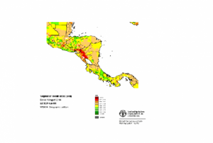
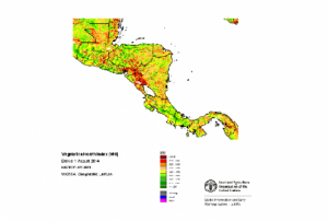
The Agricultural Stress Index System (ASIS) is based on 10-day (dekadal) satellite data, of vegetation and land surface temperatures, from the METOP-AVHRR sensor at 1 km resolution. Data for Country-level ASIS is freely available for download from FAO FTP. Time Series Database from 1984.
read morePublishing institution: ,
,  ,
, 
CEMS is a core service of the European Union’s Earth Observation programme Copernicus. It supports all phases of the disaster management cycle by delivering warnings and risk assessments of floods and forest fires and by providing geospatial information derived from satellite images on the impact of natural and man-made disasters all over the world (before, during or after a crisis). The two Mapping services of CEMS (Rapid Mapping, Risk and Recovery Mapping) are delivering products since April 2012. The Risk & Recovery Mapping provided for example information for preparedness, disaster risk assessment and risk reduction related to earthquakes in Nepal, several post-disaster assessments for flood and fire events, reconstruction and recovery monitoring in Haiti, and multi-risk assessments for the Azores Islands in Portugal.
CEMS is coordinated by the European Commission (joint coordination between the Directorate Generals ECHO, JRC, GROW). Activation requests...
read morePublishing institution: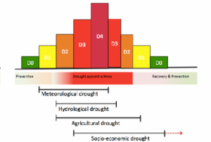 ,
, 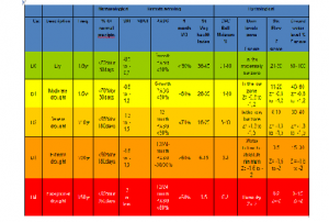
Drought classification framework based on a suite of indicators is proposed for South Africa calibration and national adaptation process
read morePublishing institution: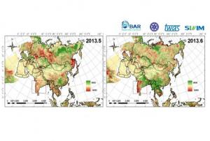
The Drought-Watch Indices module can calculate five EO-derived drought indices (VCI, TCI, VHI, NDWI, NDDI, and VSWI) and two meteorological indices (SPI and AI) in four temporal scales (day, pentad, dekad and month) by the composition parameters. Both single index and combination index are applied for the drought classification in drought module and the results are demonstrated and saved in different forms.
Publishing institution:
A break in the heat wave that hit Europe in the summer of 2018 is giving a reprieve to many people who had been suffering from the heat. However, great damages to the vegetation and harvest remain. In Germany, the Association of Farmers has reported damages from the dry spell of over EUR 1 billion. Vegetation growth in various regions and whether there is a long-term trend in vegetation development can be assessed using satellite imagery. Identifying regions that are susceptible to drought are important for drought early warning systems and disaster preparedness. In general, the analysis of satellite imagery is based on the spectral reflectance of the surface of the Earth which differs for different surface types such as soil and vegetation. For detecting...
read more17/08/2018
According to a recent report published by the International Centre for Integrated Mountain Development (ICIMOD), space-based information can play a key role in the monitoring of agricultural droughts and forest fires. The "Building Mountain Resilience: Solutions from the Hindu Kush Himalaya" report examines the changing problems facing the Himalayan region of South Asia and highlights the potential for technologies, including space-based applications, to inform communities, practitioners, decision-makers and governments alike, and build more resilient mountain communities.
The "Building Mountain Resilience: Solutions from the Hindu Kush Himalaya" report can be read here.
Citizens living in mountainous areas are impacted greatly by rising temperatures, dwindling natural resources, and rapidly increasing outmigration. The report addresses...
read moreRegional Support Offices mentioned:15/08/2018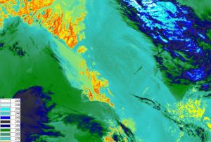 The main objective of the SENTINEL-3 mission is to monitor sea and land surface
temperature, sea surface topography and ocean and land surface colour with high accuracy and reliability. The high resolution data is meant to support ocean forecasting systems, environmental monitoring and climate monitoring.
ESA and EUMETSAT will jointly operate the SENTINEL-3 mission and bothy institutions provide access to the processed data.
Sentinel 3 carries four main instruments: the OLCI, SLSTR, Altimetry and a MWR Microwave Radiometer.
Publishing institution:
Term Parents
UN-SPIDER Regional Support Offices with hazard-specific expertise
![]()