![]()
United
Nations
Sécheresse
 instrument aboard ESA’s Envisat satellite. Image: ESA, CC BY-SA 3.0 IGO.")
Definition
Facts and figures
Further information
UN-SPIDER Regional Support Offices with hazard-specific expertise
Related content on the Knowledge Portal
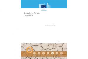
The European Commission’s Joint Research Centre today published the “Drought in Europe - July 2022” report, an assessment of Europe’s drought situation based on the European Drought Observatory.
The analysis of the evolution and impact of the prolonged drought in the EU shows that a staggering portion of Europe is currently exposed to warning (44% of EU+UK) and alert (9% of EU+UK) drought levels, associated with soil moisture deficit in combination with vegetation stress.
[...]
The Joint Research Centre produces real-time drought information through the European and Global Drought Observatories (EDO and GDO), which are part of the…
read more19/07/2022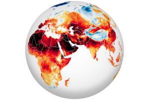
In June and July 2022, heatwaves struck Europe, North Africa, the Middle East, and Asia, as temperatures climbed above 40 degrees Celsius (104 degrees Fahrenheit) in places and broke many long-standing records.
The map above shows the surface air temperatures across most of the Eastern Hemisphere on July 13, 2022. It was produced by combining observations with a version of the Goddard Earth Observing System (GEOS) global model, which uses mathematical equations to represent physical processes in the atmosphere.
“While there is a clear pattern of an ‘atmospheric wave’ with alternating warm (redder) and cool (bluer) values in different locations, this large area of extreme (and record breaking) heat is another clear indicator that emissions of greenhouse gases by human activity are causing weather extremes that impact our living conditions,” said Steven…
read more18/07/2022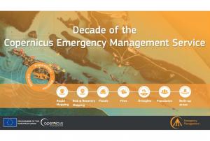
Implementing science to save lives: A Decade of the Copernicus Emergency Management Service
The Copernicus Emergency Management Service (CEMS) celebrates a decade of operation as a world leader in emergency mapping, early warning tools and open-access disaster information.
For the past ten years, CEMS has provided a global service as a fully operation emergency mapping service at no cost to users and with open access data.
Some highlights on the contribution of CEMS in global disaster risk management activities:
- 576 Rapid Mapping Activations with 5,500+ maps delivered
- Designed and implemented the world’s first Global Flood Monitoring tool
- Ten years of wildfire forecasts up to ten days into the future
- Average of 200+ flood and 500+ flash flood notifications to Member States and authorised users each year
- Offers a current and historical database of 7,000+ drought episodes since 1950
…
read more22/06/2022
UN-SPIDER's Regional Support Office of Pakistan (SUPARCO) has provided a new Recommended Practice, using Google Earth Engine to identify the drought extent and severity by calculating different indices.
Drought is a slow on-set disaster which affects agriculture and associated livelihood in many parts of the world. It causes stress to vegetation; hence the extent of a drought can be reflected by changes in the vegetation condition. Geospatial scientists have developed drought indices based on remote sensing data to effectively detect drought conditions.
Droughts make considerable effects on agricultural and agro-pastoral areas due to their substantial dependency on rainfall. Agricultural drought monitoring is very important to maintain food security in the world. Satellite remote sensing is widely used for vegetation health monitoring and has become a powerful…
read moreRegional Support Offices mentioned:20/05/2022
On 10 May 2022, the United Nations Office for Outer Space Affairs (UNOOSA), the University of Energy and Natural Resources of Ghana, and the Prince Sultan Bin Abdulaziz International Prize for Water (PSIPW) inaugurated the 5th International Conference on the Use of Space Technology for Water Resources Management. The conference, held in Accra from 10 to 13 May 2022, aims to promote the use of space technology in water management in developing countries.
During the opening segment of the conference, high ranking authorities noted that there have been many success stories related to the Sustainable Development Goals (SDGs), but unfortunately some of these were eroded by the COVID 19 pandemic. They remarked that Ghana is hosting this conference to see how best to foster new partnerships to address the SDGs, and to facilitate a constructive discussion on two key issues essential to sustainable development: Space technologies and sustainable use of water…
read more12/06/2022, March 6, 2021 - February 5, 2022")
On the Iberian Peninsula Portal and Spain are facing a severe drought, that started in November 2021 and worsened in the following months. Officials in Portugal were forced to limit the use of hydroelectric dams for power production and irrigation, as some reservoirs started reaching significant lows.
The extreme dimension of this event gets revealed on a pair of Landsat 8 OLI (Operational Land Imager) images, operated by NASA and USGS, comparing the state of the Alto Rabagão and Alto Lindoso reservoirs in northern Portugal from March 2021 to February 2022.
read more21/02/2022
África del Sur está expuesta a amenazas hidrometeorológicas, geológicas, costeras y biológicas. En los últimos años la región ha sufrido los impactos de sequías, inundaciones y plagas de langosta. La tormenta tropical Idai provocó inundaciones severas en Mozambique, Malawi y Zimbabue en marzo del año 2019 y en el año 2020 varios países tuvieron que afrontar la plaga de langosta. Desafortunadamente, COVID-19 sigue impactando a todos los países de esta región.
Para continuar promoviendo el uso de tecnologías espaciales en actividades relacionadas on la gestión para la reducción de riesgo de desastres, la preparación, la respuesta y la recuperación en caso de desastres, ONU-SPIDER y el Centro de Percepción Remota de Superficies Terrestres de la Universidad de Bonn (ZFL por sus siglas en inglés) unieron esfuerzos para organizar la Reunión Regional Virtual de Expertos para África del Sur: "Soluciones Espaciales para Gestión de Riesgo y Respuesta en caso…
read moreRegional Support Offices mentioned:19/07/2021-
Southern Africa is exposed to hydrometeorological, geological, coastal and biological hazards. The region has been hard hit by droughts in recent years. Tropical cyclone Idai triggered massive floods in Mozambique, Malawi, and Zimbabwe in March 2019, and in 2020 several countries experience a severe locust outbreak. And unfortunately, COVID-19 continues to impact all countries in this region.
To continue efforts to promote the use of space technologies in disaster risk management, emergency response and recovery efforts, UN-SPIDER and the Centre for Remote Sensing of Land Surfaces of the University of Bonn (ZFL) joined forces to organize the UN-SPIDER / ZFL Regional Virtual Expert Meeting for Southern Africa "Space-based Solutions for Disaster Risk Management and Emergency Response" from 13 to 15 July 2021. This regional expert meeting contributed to the efforts conducted by UN-SPIDER on disaster risk reduction, preparedness, early warning…
read moreRegional Support Offices mentioned:19/07/2021 
Droughts have extensive and profound repercussions on populations, livelihoods, ecosystems, and economies. The most vulnerable people are unduly affected by their financial consequences. Although droughts affect millions, lead to food shortages, poverty, and inequality, their immense and widespread effects are often underreported.
Climate change is aggravating the intensity, duration, and prevalence of droughts globally through rising temperatures and disturbances of rainfall patterns. Within the next 80 years, climate change will be the primary cause of the increased drought exposure of 129 countries (Smirnov et al., 2016). As global temperatures rise due to climate change, pressing action is needed to manage the risks related to droughts, and to diminish their destructive impact on human lives, livelihoods, and ecosystems.
On 17 June 2021, the United Nations Convention to Combat Desertification (UNCCD) celebrated the …
read more18/06/2021
Space-based applications related to Earth Observation and geospatial data play an important role in supporting disaster risk reduction, response and recovery efforts through providing accurate and timely information for decision-makers. Monitoring floods, drought conditions and water resource environments using satellite remote sensing (RS) technologies have become more essential recently, in particular for developing countries.
The workshop will be held in Tehran, Iran, from 9 to 11 August 2021, in a virtual format, and will be hosted by the Iranian Space Agency (ISA). The workshop will explore how current space technologies help identify and monitor the effects of a changing climate – including the onset of drought, flash floods, and general water resources conditions as a result of global climate change, in particular on an international and regional scale. The discussions at the workshop will also be linked to the 2030 Agenda for…
read moreRegional Support Offices mentioned:14/06/2021
UN-SPIDER Regional Support Offices with hazard-specific expertise
![]()