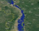
In the end of January 2022, Tropical Storm Ana caused severe floods in Madagascar, Malawi, and Mozambique.
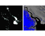
UN-SPIDER supported Malawi’s Department of Disaster Management Affairs (DoDMA) and the UN Resident Coordinator's Office in Malawi by creating flood delineation products based on Sentinel-1 data, using UN-SPIDER's recommended practices on radar-based flood mapping.