This is event is available for participation on an ongoing basis
The 9th International Conference on Remote Sensing and Geoinformation of Environment (RSCy2023) will be held in Cyprus on 3-5 April, 2023.
The RSCy2023 is organized by the Cyprus Remote Sensing Society and ERATOSTHENES Centre of Excellence, in cooperation with ESA, NASA, Copernicus, DLR, Group On Earth Observations, the Department of Electronic Communications of the Ministry of Communications and Works, the Technical Chamber of Cyprus, the Cyprus Department of Meteorology and the Agricultural Research Institute.
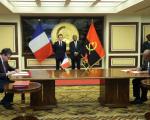
On March 3, Airbus Defence and Space announced a manufacuring agreement for Angeo-1, the first Angola Earth Observation satellite. Angeo-1 will be an Airbus S250 optical satellite built in France, and once operational it will become the most advanced optical satellite in the region.
This is event is available for participation on an ongoing basis
FOSS4G, the Free and Open Source Software for Geoespatial and the largest global gathering for geospatial software, is taking place in Prizren, Kosovo, from 26 June to 2 July 2023. During seven days of presentations, discussions, workshops, and cooperation, FOSS4G brings together developers, users, decision-makers and observers from a diverse array of opganizations and fields.
The conference will cover many topics, amongst which:
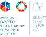
The VIII Regional Platform for Disaster Risk Reduction in the Americas and the Caribbean (RP23) has successfully concluded in Punta del Este, Uruguay. The event was held in a hybrid format from February 28 to March 2, 2023, under the theme, “Science and Technology for Integrated Disaster Risk Management”. The Government of Uruguay hosted the forum, which aimed to bring together a wide range of stakeholders to discuss and address the issue of disaster risk reduction.
This is event is available for participation on an ongoing basis
The United Nations World Data Forum (UNWDF), which will be held in Hangzhou, China from 24 to 27 April 2023, is inviting Member States, civil society, the private sector, UN agencies, and other organizations to showcase their good practices and success around the four themes of the Forum.
With over 100 events, 70 parallel sessions, 30 learning labs, and exhibits, the Forum will bring together experts and stakeholders from around the world to discuss and exchange ideas on the latest trends, challenges, and opportunities related to global data.
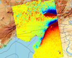
Zambia is a drought-prone country that experiences droughts every 4 to 5 years. This frequency is projected to increase due to climate change. The inadequate infrastructure together with the rural and poor population makes the country highly vulnerable to droughts.
Southern and Central provinces in Zambia are underwater after long-term rainfall starting 11 January, causing overflowing rivers. The floods, reported as “catastrophic” by Zambia’s Disaster Management and Mitigation Unit, have caused widespread damage to homes, farmland, and livestock. The floods have also left numerous communities isolated and sanitation facilities completely submerged, exposing the population to a high risk of waterborne diseases.
The United Nations Platform for Space-based Information for Disaster Management and Emergency Response (UN-SPIDER) in collaboration with the German Aerospace Centre (DLR), the Global Flood Awareness System (GLOFAS) of the Copernicus Programme of the European Commission, and the University of Bonn’s Centre for Remote Sensing of Land Surfaces (ZFL), conducted an international training workshop on space-based technologies for flood management. The workshop was held at the UN Bonn Campus on 20-22 February 2023.
This is event is available for participation on an ongoing basis
Geospatial technologies and remote sensing are valuable resources to monitor the United Nation's Sustainable Development Goals (SDGs) and their corresponding targets and indicators. They allow for unbiased observation and analysis across borders, administrative boundaries, and nations. Furthermore, geospatial information and technologies are particularly critical to strengthening urban and rural resilience, where economic, agricultural, and various social sectors intersect.
Turkey and Syria recently experienced two devastating earthquakes of magnitude 7.8 and closely followed by a magnitude 7.5, resulting in extensive damage and destruction. The International Charter 'Space and Major Disasters' was activated by Turkish authorities, the United Nations, and the International Federation Red Cross & Red Crescent Societies in response to the earthquakes. The Charter provided more than 350 crisis images from 17 space agencies worldwide, which were used to create damage and situation maps to estimate the hazard impact and support relief actions.