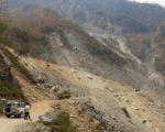
Estimate Hectares of Forest Destroyed or Damaged by Fire for the Sendai Framework Indicator C-2Fo

Fires continue to destroy thousands to hundreds of thousands of hectares of forests and wildlands around the world every year.  Furthermore, the United Nations Development Programme (UNDP) recognises that global warming will lead to an increase in the number and severity of forest fires in years to come. As a first step to address the challenges of wildfires, it is important to assess their geographical location and their severity.  This information can be useful to implement restrictions on land use and to identify measures to ensure the recovery of such wild areas.   

The Global Wildfire Information System (GWIS) is a joint initiative of the Group on Earth Observations (GEO) and Copernicus Work Programs. GWIS aims to bring together existing information sources at the regional and national levels in order to provide a comprehensive evaluation of fire regimes and fire effects at a global scale, and support operational wildfire management from national to global levels. In 2021, GWIS launched its Country Profiles application which provides national-level statistics and historical data of fires, including yearly burned area by landcover class statistics generated from MODIS and ESA land cover products.

The historical data included in GWIS can be used to track the historical trends of forest fires in any country of the world in the last two decades.  Such data can be used to elaborate an ad-hoc indicator for the Sendai Framework Monitor that governments use to report on progress in the implementation of this framework.  The Sendai Framework includes seven targets and indicators have been designed to capture trends over the years.  One of those indicators addresses the trends in the number of hectares that have been burnt on an annual basis.  

This page provides a practical use of GWIS for national focal points to report on the number of hectares of forests damaged/destroyed by fire in reference to Target C of the SFDRR where country data for estimating directing economic loss is not available.

This procedure is designed to be used by those staff at government agencies in charge of compiling and entering information related to specific Sendai Framework indicators. Specifically, for those who have to enter data on indicator C-2Fo related to the impact of wildfires. 

The Sendai Framework for Disaster Risk Reduction 2015-2030 (SFDRR) is the global blueprint for disaster risk reduction (DRR), which recognises that each State has the primary responsibility to prevent and reduce disaster risk, including through international, regional, subregional, transboundary and bilateral cooperation. Member states are encouraged to report on their progress towards the seven Sendai Framework global targets using the online Sendai Framework Monitor (SFM).

Geographical applicability:

This Ad-hoc indicator can be applied in most countries of the world, at the national or provincial level.

UN-SPIDER RSOs celebrate the International Day for Disaster Risk Reduction

As recognized in the Sendai Framework for Disaster Risk Reduction 2015-2030, and by the United Nations Office for Disaster Risk Reduction, international cooperation is essential to contribute to the efforts carried out in developing countries to achieve sustainable development.

International Day for Disaster Risk Reduction 2021

Disasters triggered by natural and technological hazards continue to impact communities worldwide.  Nevertheless, communities, institutions of the civil society, academia and the private sector, government agencies, regional, and international organizations are working together to address the challenges posed by disasters through risk reduction efforts. Today, 13 October 2021, communities around the world are celebrating the International Day for Disaster Risk Reduction.

UN-SPIDER/ESA/EC/CEU Training course for Master's Students on Assessment of Floods and Burned Areas

This is event is available for participation on an ongoing basis

The aim of the training course is to introduce students to the use of the RUS platform virtual machine to generate maps of the geographical extent of burned areas due to forest fires and floods with practical examples from recent events in Europe.  It will give students enrolled in a Master´s programme an opportunity to experience working with satellite images for disaster management purposes. 

0
0
No certificate issued or not known
0.00
USD
11/18/2021, 12:00am - 11/19/2021, 12:00am
Visible

UN-SPIDER, ESA, Central European University (CEU), and Copernicus RUS

Central European University (CEU)

The Central European University (CEU) was founded in 1991 and is known for excellence in teaching and research—with purpose. At the core of its mission lies a set of principles: the pursuit of truth wherever it leads, respect for the diversity of cultures and peoples, and commitment to resolve differences through debate not denial.

Since several years ago, CEU has joined forces with UN-SPIDER to carry out training courses on the use of space technologies in disaster management to train a new generation of professionals. 

0
0
UN-SPIDER/ESA/EC/CEU Virtual Training Course for students: Assessment of Floods and Burned Areas juan-carlos.vi… Fri, 1 Oct 2021 - 09:17

WMO releases Atlas of impacts of weather, climate and water extremes 1970–2019

On 31 August 2021, the World Meteorological Organization (WMO) launched its Atlas of Mortality and Economic Losses from Weather, Climate and Water Extremes (1970–2019).  This publication presents information on the impacts of extreme weather, climate and water-related events that took place between 1970 and 2019.  It presents historic data on impacts provoked by storms, floods, droughts, extreme temperature, landslides, wildfires, and other hazards.  Impacts are expressed in terms of fatalities and economic losses.

ARSET - Agricultural Crop Classification with Synthetic Aperture Radar and Optical Remote Sensing

This is event is available for participation on an ongoing basis

For years, mapping of crop types and assessment of their characteristics has been carried out to monitor food security, inform optimal use of the landscape, and contribute to agricultural policy. High-quality crop mapping has become a requirement for most nations given its importance in national and international economics, trade, and food security, and is a major topic of interest in the domains of policy, economics, and land management.

0
0
No certificate issued or not known
0.00
USD
10/05/2021, 12:00am - 10/19/2021, 12:00am
not visible

NASA’s Applied Remote Sensing Training Program (ARSET), Agriculture and Agri-Food Canada (AAFC), European Space Agency (ESA), Indian Space Research Organisation (ISRO), and United Nations Office for Outer Space Affairs (UNOOSA).

1

UN-SPIDER Bonn International Conference, 16 to 18 November 2021

Natural and man-made disasters continue to cause tremendous damage to societies around the world. While the COVID-19 pandemic continues to impact all countries around the world, the effects of climate change on hydrometeorological and other hazards cannot be ignored. The trend of very intense forest fires that took place in 2019 in Australia, Brazil and the United States continued this year in Greece, Turkey, and other countries; and regions of Germany saw the impacts of unprecedented floods and debris flows that triggered massive losses.

2021 PACE Applications Workshop

This is event is available for participation on an ongoing basis

The NASA Plankton, Aerosol, Cloud, ocean Ecosystem (PACE) Applications team invites the research, applied sciences, and decision-making communities to the 2021 PACE Applications virtual workshop held September 15th-16th at 10:00a ET.

This 2-day event will focus on future uses of PACE satellite data, products, and applications to benefit society and support decision-making in the context of water resources, air quality and health, climate, disasters, and ecological forecasting.

0
0
No certificate issued or not known
0.00
USD
09/15/2021, 12:00am - 09/16/2021, 12:00am
not visible

NASA Plankton, Aerosol, Cloud, ocean Ecosystem (PACE) Applications team.

1