![]()
United
Nations
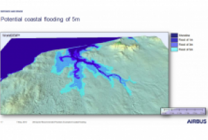
Inundación
, processed by ESA, CC BY-SA 3.0 IGO.")
Definition
Facts and figures
Further information
UN-SPIDER Regional Support Offices with hazard-specific expertise
Related content on the Knowledge Portal
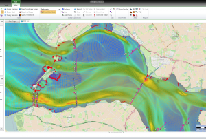
 Storm surges and tidal waves are global phenomena that considerably affect human populations in coastal and island regions. According to the Guide to Storm Surge Forecasting published by the World Meteorological Organization in 2011, storm surges can be defined as “oscillations of the water level in a coastal or inland body of water in the time range of a few minutes to a few days, resulting from forcing from atmospheric weather systems. According to this definition, the so-called wind waves, which have durations on the order of several seconds, are excluded”. Storm surges are a coastal...
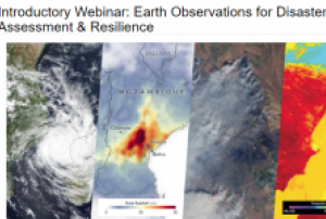
The training date is in the past. However, videos and resources of the training can be accessed here.
According to a UN report, between 1998 and 2017, the U.S. alone lost $944.8 billion USD from disasters. Between 1978 and 2017, losses from extreme weather events rose by 251 percent. It is critical to develop disaster management strategies to reduce and mitigate disaster risks. A major factor in regional risk assessment is evaluating the vulnerability of lives and property to disasters. Environmental information about disasters, their spatial impact, and their temporal evolution can play an important role as well.
This webinar series will focus on Earth observation (EO) data useful for disaster risk assessment. The series will cover disasters including tropical cyclones, flooding, wildfires, and heat stress...
read more Publishing institution:
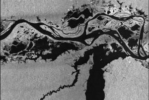 Publishing institution:
The Global Flood Partnership is a multi-disciplinary group of scientists, operational agencies and flood risk managers focused on developing efficient and effective global flood tools that can address these challenges. Its aim is to establish a partnership for global flood forecasting, monitoring and impact assessment to strengthen preparedness and response and to reduce global disaster losses.
The registration for the 2019 Global Flood Partnership Annual Meeting is open! This year's meeting will take place on 11 - 13 June 2019 in Guangzhou, China hosted by Sun Yat-sen University.
read moreAn updated draft agenda is available and can be found here.
Instructions for participants are available ...
Flood Risk Management is by definition dealing with uncertainty. Floods occur often enough, but the timing and location of flood events are uncertain, and so is the response of society. But the concepts and methods of flood risk analysis and management are progressively tuned to deal with this kind of uncertainties.
This challenge of scientific innovation and practical adaptation is too big for the current generation of scientists and practitioners. FLOODrisk2020 is therefore committed to attract, coach and listen to the next generation of scientists and practitioners who will future-proof our research methods and help to improve our flood risk management practice in order to better cope with deep uncertainty and therefore the 4th conference will focus on the issue of Science and practice for an uncertain future.
read more
This webinar focuses on Flood History and - Risk as well as on Land Motion (subsidence), but related topics that will be touched upon are LU/LC and Change, Transport Infrastructure and Green Urban areas, as these are also relevant for assessing sustainability of cities with respect to Climate Resilience and Disaster Management. During the webinar use cases and applications of EO based solutions are demonstrated for several cities.
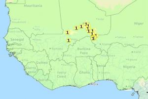 This interactive portal provides near real time data on potential floods that will potentially affect countries in West Africa. The data has a maximum of 10 day forecast and includes flood categories 2-year, 5-year, and 30-year return periods.Publishing institution:
, EMSN024, EMSN056)")
To meet the global challenges, the United Nations adopted several framework agreements, including the Sendai Framework for Disaster Risk Reduction at the Third United Nations World Conference on Disaster Risk Reduction (2015-2030). The framework builds the international reference point for disaster preparedness and focuses on reducing existing and future disaster risks as well as enhancing disaster resilience. In the Sendai framework, seven global targets have been agreed to measure global progress in implementing the framework through quantifiable indicators and to present, compare and evaluate the status and progress uniformly worldwide. The recording of the status and degree of target achievement using the agreed indicators requires the use of various data sources, which must be consistent and comparable in time and space in order to ensure global monitoring.
Publishing institution:
Term Parents
UN-SPIDER Regional Support Offices with hazard-specific expertise
![]()