![]()
United
Nations
Tormenta severa

Definition
Facts and figures
Further information
UN-SPIDER Regional Support Offices with hazard-specific expertise
Related content on the Knowledge Portal

On 1 April 1960, NASA sent the Television Infrared Observation Satellite (TIROS-1) into space. TIROS-1 was developed during the 1950s and, after years of experimental programmes and attempts, became the world’s first weather satellite. Since weather satellites were a new technology at that time, the mission also tested various design issues for spacecraft, such as instruments, data, and operational parameters, in order to improve satellite applications for Earth-bound decisions. TIROS-1 thus paved the way for further weather satellite development and research. Today, weather satellites provide highly accurate and near-real-time measurements that can efficiently monitor and forecast extreme weather events, such as floods and droughts, as well as enhance the understanding of the climate and of the Earth as a whole.
...
read more16/04/2020
The Japan Aerospace Exploration Agency (JAXA) has released the JAXA Climate Rainfall Watch website to monitor extreme weather and climate over the world. The website provides hourly global measurements of precipitation as well as forecasts about heavy rainfall and drought in different temporal scales (daily, pentad, weekly, 10-days and monthly). The satellite-based global rainfall maps produce highly accurate measurements that can help better understand the changing climate, improve forecasts of extreme weather events, such as floods and droughts, minimize their damage and strengthen early warning systems.
The Climate Rainfall Watch website monitors heavy rainfall and drought in near-real-time and collects and stores data from previous months. The website calculates rainfall in percentile: heavy rain is indicated by...
read more15/04/2020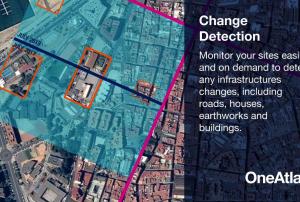 OneAtlas is a collaborative environment to easily access very high resolution imagery, perform large-scale image processing, extract industry specific insights and benefit from Airbus assets to develop solutions. The services include infrastructure change detection, vehicle detection & counting and will soon cover aircraft detection and land use change detection as well . Airbus provides the services through a buy-what-you-need option. It is possible to test the functionalities with a 30-days Free Trial.Publishing institution:
 on NASA’s Aqua satellite captured this natural-color image of Hurricane Dorian at 2:05 p.m. Eastern Daylight Time (18:05 Universal Time) on 1 September 2019. Image: NASA.")
Hurricane Dorian, a category 5 hurricane, made landfall at Elboy Cay, Abaco, Bahamas, on 1 September. The hurricane had devastating effects, especially on the islands of Grand Bahama and Abaco, as they had prolonged exposure to extreme hurricane force winds, storm surges, flooding and intense rainfall.
The Abaco Islands and Grand Bahama, in the north of the archipelago, were battered by the storm for two days which decimated whole areas, leaving houses without roofs, scattered debris and flooding as up to 35 inches of rain fell.
Dorian is the strongest hurricane on record to make landfall in Bahamas and caused massive storm surges and flooding of entire villages, destroyed thousands of homes, downed power and telecommunication lines, put health facilities out of action, made roads impassable and contaminated the drinking water system with salt water.
Both the...
read more
Tropical storms have major impacts, including loss of life and destruction of property. In 2017 alone, the United States experienced three tropical storms with more than $1 billion in losses. Open source satellite data can be used before, during, and after a storm for monitoring and response. A storm’s intensity, path, wind, precipitation, storm surge, and flooding can be derived from historical and near real-time satellite observations. In this introductory webinar, participants will learn about the NASA data and tools they can use to monitor tropical storms.
Learning Objectives:
... read more ,
,  ,
,  ,
,  ,
, 
Upon the request of the Ministry of Territorial Administration (MINAT), Government of Cameroon, UN-SPIDER carried out a week-long Institutional Strengthening Mission (ISM) to Yaoundé from 15 to 19 July. The mission aimed to strengthen the capacities of the Department of Civil Protection (DPC) of Cameroon in using space-based information in all phases of the disaster management cycle. It was the third UN-SPIDER mission to Cameroon after a Technical Advisory Mission (TAM) in 2011 and an Institutional Strengthening Mission (ISM) in 2012, the latter including a training course on “Remote Sensing for Disaster Management”.
During the mission, UN-SPIDER experts and an expert from its Nigeria Regional...
read moreRegional Support Offices mentioned:22/07/2019- Tropical Cyclones stalling along the North Atlantic coast lead to more rain in the confined location
. Image: NASA Earth Observatory.")
According to a new study by scientists from NASA and NOAA, tropical cyclones stall more frequently and stay longer near the coastline. This potentially leads to more precipitation over confined locations and thus an aggravation of tropical cyclone hazards for coastal populations.
In the new study, scientists Hall and Kossin examined all tropical cyclones from 1944-2017 in the National Hurricane Center's HURDAT2 database to analyze the position and calculate the average forward speed of each storm that has reached the coastal regions and to investigate the direction of the storm track. They found that 66 storms in the North Atlantic stayed in a coastal region for more than two days. Almost half of these 66 stalls appeared in the last third of the 74 years they analyzed, while only 17 appeared in the first third. In addition, they found that long-lasting storms were more likely to contain meanders.
The trajectory of a tropical cyclone...
read more04/07/2019 .")
A recent study, published in the Water Resource Research journal, presents a new method for a spatially realistic national flood risk assessment.
Researchers expanded an existing statistical model, based on U.S. Geological Survey (USGS) river flow data, to simulate a thousand years of potential flood events. By calculating the damage for each event in dollars, they were able to estimate the probability of the United States suffering particular annual flood damages.
Traditional risk flood analysis models assume that the impacts on the entire flood-affected area are the same, but flooding can be more severe in some areas than in others, even during the same flood event. At national scales, traditional risk analyses can only estimate the average annual loss. To estimate the total annual losses that might occur in more extreme flooding...
read more04/07/2019
In the past year, “there were 315 natural disaster events recorded with 11,804 deaths, over 68 million people affected, and US$131.7 billion in economic losses around the world.” This is according to the Centre for Research on the Epidemiology of Disasters (CRED) in its recently released 2018 Natural Disasters Report.
While these 2018 natural disaster values represent a decrease when compared with the annual averages from 2008 to 2017, some geographic areas still experienced great losses of life and damages due to natural hazards. Indonesia was most adversely impacted in terms of lives claimed, with earthquakes in August and September 2018 that left a total of 4,904 people dead or missing, according to the CRED. Earthquakes also accounted for the greatest number of deaths among natural disasters worldwide in 2018. And among all types of natural hazards, floods affected the greatest number of people during the...
read more01/07/2019 Storm surges and tidal waves are global phenomena that considerably affect human populations in coastal and island regions. According to the Guide to Storm Surge Forecasting published by the World Meteorological Organization in 2011, storm surges can be defined as “oscillations of the water level in a coastal or inland body of water in the time range of a few minutes to a few days, resulting from forcing from atmospheric weather systems. According to this definition, the so-called wind waves, which have durations on the order of several seconds, are excluded”. Storm surges are a coastal...
Term Parents
UN-SPIDER Regional Support Offices with hazard-specific expertise
![]()