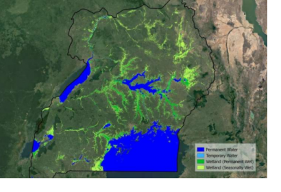
The European Space Agency’s (ESA) GlobWetland Africa project has produced maps that demonstrate how satellite observations can be used for the effective use and management of wetlands in Africa. The project, created in collaboration with the African Team of the Ramsar Convention on Wetlands, provides national and international stakeholders with the necessary satellite-based methods and tools useful for the conservation and effective management of wetlands.
The initiative provides a software platform built on the free and open-source QGIS geographic information system (GIS). The platform shows how optical and radar observations combining long-time data sets from different satellites can be used for studying wetland status and trends. For instance, the project shows how it is possible to map wetland habitat using a Random Forest (RF) classification of multi-spectral satellite imagery from Sentinel-2 and Landsat (TM, ETM, OLI). To identify wetland inventory, the initiative suggests using a multi-temporal classification approach with optical and radar data from Sentinel-2 and Landsat 8. Similarly, the same approach using Sentinel-2, Sentinel-1 (optional) and Landsat (TM, ETM, OLI) can be helpful to identify the inundation regime. To monitor wetland ecosystem changes, Sentinel-3 and MERIS FR can be used to analyse water quality parameters. To map mangrove extent, the project suggests to use characterization maps derived using supervised machine learning algorithms (i.e. Random Forest and Support Vector Machine) that takes a set of training data to establish the relationship between optical data and data from Sentinel-3 OLCI FR and MERIS FR.
The sustainable management of wetlands, and the restoration of those which have been degraded, can help reduce the impact of hazards and help communities recover from disasters. Coastal wetlands, for instance, act as protective barriers against waves, storm surges and tsunamis, whereas inland wetlands function like sponges, absorbing and storing excess rainfall and reducing flood surges. Healthy peatlands store carbon and thereby mitigate the impacts of climate change. Wetlands act also as natural buffers, reducing the impact of disasters by collecting and holding water during floods, releasing water to reduce droughts, and protecting coastal communities against storm surges. Wetlands can also speed up the recovery process following a disaster by acting as natural water filters and nutrient restorers, or by releasing the water stored which helps delay the onset of droughts and minimizes water shortages.

